


|
||

|

|
|

|
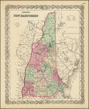
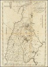
The Earliest Obtainable Printed Map of the State of New Hampshire
Rare and attractive 1791 map of New Hampshire engraved in Boston by Samuel Hill.
The map shows towns, county boundaries, and "Line of Masons Patent, 1787." According to Cobb, the acreage of the Dartmouth Grant has been changed from the original manuscript.
Belknap's map is the third printed map of the State of New Hampshire, following Samuel Holland's A Topographical Map of the State of New Hampshire, first published in 1781 (Province of New Hampshire), with the second state changing "Province" to "State" in 1784 and a similarly titled map, published in Boston in about 1788.
States
The map was reprinted in 1812 or '13 with the note '42,000 Acres | to Dartmouth College.' altered to read '40,960 Acres | to Dartmouth College.'
![(California Gold Rush Artist) [Autograph Letter, from American artist William McIlvaine Jr. to artist William Thompson Russell Smith, mentioning Fronconia Notch. White Mountains]](https://storage.googleapis.com/raremaps/img/small/97179.jpg)