|
||

|

|
|

|
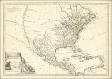
Interesting edition of Mitchell's atlas map of the United States, published at the end of the Civil War.
The map includes a massive Idaho Territory, pre-dating the formation of Montana and Wyoming Territories.
This map illustrates the evolving west, most notably the oversized Idaho Territory, which extends from Oregon and Washington to Dacotah. The map shows early explorers' routes, forts, Indians, railroads, towns, rivers, mountains, etc. Very decorative. Insets of Pensacola and Hampton Roads/Norfolk.
After a 10 year hiatus, the Mitchell Family reacquired control of the atlas which Samuel Augustus Mitchell published from 1845 to 1849. The 1860 edition abandoned the Desilver decorative border and launched a new version of the atlas which endured until the early 1890s.
Samuel Augustus Mitchell Jr. inherited the Mitchell Company from his father in 1860. For over thirty years, the company had specialized in the production of school atlases and wall maps of America. They were one of the pioneers on engraving on steel plates. In 1860, Samuel Jr. released the New General Atlas, which had been compiled in house and replaced a previous atlas by Tanner. The elder Mitchell died in 1868 and Samuel Jr. continued the business until the 1890s. At its height, the Mitchell Company employed 250 people and sold 400,000 publications annually.

![Vereinigte Staaten von Nord-Amerika [Views of New York City and Back Country Scenes]](https://storage.googleapis.com/raremaps/img/small/25442.jpg)