


|
||

|

|
|

|
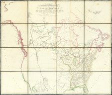
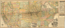
A Seminal Western Map
Fine original wash color example of Aaron Arrowsmith's map of North America, one of the seminal maps for the early history of the Transmississippi West.
First issued in 1795 as a four sheet map, Arrowsmith expanded the map by adding 2 lower sheets in 1802, thereby covering most what would become the United States and Canada. Over the next several decades, the map would be regularly updated with information from early American and British explorers, Hudson Bay Company traders, fur traders and host of other sources. The earliest 19th century explorations and discoveries of the Transmississippi West reveal themselves in Arrowsmith's maps, with R.V. Tooley noting a total of 15 recorded states.
The present example of Arrowsmith's map, with additions to 1811, is 8th State according to Tooley. The map is nearly identical to the state of Arrowsmith's map which Lewis & Clark brought on their expedition across the Rocky Mountains to the Pacific, which they consulted during the first leg of their journey in search of the headwaters of the Missouri (the only printed map which they took on the expedition). Three journal entries of Merriwether Lewis in early June 1805 specifically reference the expedition's attempts to reconcile the contents of Arrowsmith's map with the information provided by the local Indians in order to determine which of the branches of the Missouri might provide the best possible portage through the Rocky Mountains.
Aarron Arrowsmith benefitted extensively from his relationship with the Hudsons Bay Company (HBC). Arrowsmith's map was the first map to name the Rocky Mountains. In the northern portion of the Rocky Mountains, it was the first map to incorporate HBC explorer and fur trader Peter Fidler's rivers extending from the Mandan Villages to the Rocky Mountains. Because these rivers were based upon Indian accounts and not actual observations, Arrowsmith used dashed lines. Choosing among these rivers to traverse the Rocky Mountains was among the most important choices made by Lewis & Clark. Fidler's extensive contacts with the indigenous tribes on the eastern slope of the Rocky Mountains and contributed greatly to the geographical knowledge of the region. The information was transmitted through the Hudson's Bay Company channels back to England and very quickly delivered to Arrowsmith, who was then the primary mapmaker for the HBC.
Arrowsmith's map was also the first to show the Upper Missouri joined with the Mississippi River in its correct location. The ruins of Fort Orleans, built by the French fur trapper and explorer Bourgmont in the early 1700s is shown on the Lower Missouri. The course of the Missouri River, below the Kansas River to the Mississippi, is significantly improved, although above the Kansas River and the Mandan Villages, the Arrowsmith map references "the most Northern Bend of the Missesouri Rios" (an area derived from David Thompson's manuscript map of 1798).
On the far side of the Rocky Mountains, a section of river called the Great Lake River includes a speculative water course which flowed to the River Oregan (Columbia River), included a note stating that "the Indians say they sleep 8 Nights in descending this River to the Sea." This note was one more factor which led to Lewis & Clark selecting this route as a means of a locating navigable route by water to the Pacific Ocean.
The large blank areas in the west show how little was known about the lands up the Missouri River Valley and across the Rocky Mountains and reflect the blank canvas upon which the mapping of the west would be drawn over the next 4 decades. Explorers had probed the edges of the region, but Europeans had not yet penetrated the interior.
Lewis & Clark
Both the 1795 and 1802 editions of Arrowsmith's map were used by Nicholas King in his preparation of the primary manuscript map used on the Lewis and Clark Expedition, with the the later map selected for the trip. As noted by Warren Heckrotte:
On the third of June, 1804, the Lewis and Clark expeditionary party ascending the Missouri River came unexpectedly to "the junction of two large rivers." The information the two captains had obtained from the Minnatree Indians at the expedition's winter camp, Fort Mandan, near the Great Bend of the Missouri had not indicated the presence of a branch of the river at this location. The decision as to which branch was the Missouri was a critical one: the wrong choice "might defeat the expedition altogether." For the next week the captains reconnoitered the two branches. By June 10 they had decided the south branch was the Missouri. Lewis set out ahead of Clark to search for the critical text -- the Great Falls of the Missouri. On June 13 he found them . . .
DeVoto calls the reasoning of the two captains at this juncture a remarkably act of the mind that should occupy a distinguished place in the history of thought.
In their considerations the captains brought to bear the great map of North America by Aaron Arrowsmith. . . .
In making this critical decision, Arrowsmith's map was the focal point. As noted by Heckrotte:
On June 8 the journal of the expedition summarized their assessment of the relevant portions of Arrowsmith's map. Lewis believes from the map that [Peter] Fidler had descended along the eastern side of the Rocky Mountains to the "remarkable mountain" called the "Tooth" at latitude 46º north and that Fidler had not seen the Missouri on the journey, "only small streams coming down from the mountains." The captains reasoned that Fidler could not have come so far south without meeting the great river and concluded that Fidler and the map were in major error in this region.
Thomas Jefferson
Thomas Jefferson also owned the 1802 map, as well as an 1802 edition of Arrowsmith's map of the United States. Following the Louisiana Purchase, Arrowsmith's 1802 map of North America was the most comprehensive map of the West available to Jefferson and the map which inspired Jefferson's visualization of what would become known as American manifest destiny.
The information on the map also fed Jefferson's misconceptions of western geography, most notably is depiction of the Rocky Mountains as a single long chain, along with depiction of source of the Missouri River at the eastern edge of the Rockies, suggesting the prospect of an easy portage across through the mountains.
States of the Map & Rarity
Arrowsmith's map was published in a number of editions between 1795 and 1824, with the later editions by his son John Arrowsmith in 1833 and 1839.
The present state (8th state) is the only state dated 1811 and is one of the rarest.
The map would be extensively updated and revised in 1814, following the publication of the 9th State of the map, which bears the additional imprint "Additions to 1811-June 1814."
The Arrowsmiths were a cartographic dynasty which operated from the late-eighteenth century to the mid-nineteenth. The family business was founded by Aaron Arrowsmith (1750-1823), who was renowned for carefully prepared and meticulously updated maps, globes, and charts. He created many maps that covered multiple sheets and which were massive in total size. His spare yet exacting style was recognized around the world and mapmakers from other countries, especially the young country of the United States, sought his maps and charts as exemplars for their own work.
Aaron Arrowsmith was born in County Durham in 1750. He came to London for work around 1770, where he found employment as a surveyor for the city’s mapmakers. By 1790, he had set up his own shop which specialized in general charts. Arrowsmith had five premises in his career, most of which were located on or near Soho Square, a neighborhood the led him to rub shoulders with the likes of Joseph Banks, the naturalist, and Matthew Flinders, the hydrographer.
Through his business ties and employment at the Hydrographic Office, Arrowsmith made other important relationships with Alexander Dalrymple, the Hudson’s Bay Company, and others entities. In 1810 he became Hydrographer to the Prince of Wales and, in 1820, Hydrographer to the King.
Aaron Arrowsmith died in 1823, whereby the business and title of Hydrographer to the King passed to his sons, Aaron and Samuel, and, later, his nephew, John. Aaron Jr. (1802-1854) was a founder member of the Royal Geographical Society (RGS) and left the family business in 1832; instead, he enrolled at Oxford to study to become a minister. Samuel (1805-1839) joined Aaron as a partner in the business and they traded together until Aaron left for the ministry. Samuel died at age 34 in 1839; his brother presided over his funeral. The remaining stock and copper plates were bought at auction by John Arrowsmith, their cousin.
John (1790-1873) operated his own independent business after his uncle, Aaron Arrowsmith Sr., died. After 1839, John moved into the Soho premises of his uncle and cousins. John enjoyed considerable recognition in the geography and exploration community. Like Aaron Jr., John was a founder member of the RGS and would serve as its unofficial cartographer for 43 years. Several geographical features in Australia and Canada are named after him. He carried the title Hydrographer to Queen Victoria. He died in 1873 and the majority of his stock was eventually bought by Edward Stanford, who co-founded Stanford’s map shop, which is still open in Covent Garden, London today.
![The Pathfinder Railway Guide Map. Western Section [Alaska, Yellowstone Park / Philippines / Hawaii / Guam]](https://storage.googleapis.com/raremaps/img/small/97894.jpg)
![[ Atlantic Ocean / Triangular Trade / Negroland ]](https://storage.googleapis.com/raremaps/img/small/65187.jpg)