


|
||

|

|
|

|
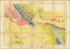
From the First U.S. Air Navigation Map Series.
This 1925 air navigation map represents a pioneering era of aerial cartography, detailing the route from North Platte, Nebraska to Cheyenne, Wyoming. Compiled and reproduced by the Engineer Reproduction Plant of the Corps of Engineers under the direction of the Airways Section Office Chief of Air Service, this map is an early artifact from the infancy of American aviation, offering detailed information on topography, infrastructure, and aerial routes.
In the post-World War I period, the United States recognized the strategic and commercial importance of aerial navigation, leading to significant advancements in aviation infrastructure and technology. The establishment of standardized air routes and navigation charts was a direct response to the increasing reliance on aircraft for mail delivery, military logistics, and passenger transport. The Air Corps' involvement in the creation of this map signifies the military's early commitment to developing a nationwide aerial network.
The map itself is a testament to the period's cartographic and aeronautical ingenuity. It includes detailed representations of terrain gradients, magnetic declinations, and various landmarks critical for navigation, such as railroads, highways, cities, and even aerial mail landing fields.
Rare.

![A Hysterical Map Of The Yellowstone Park -- With Apologies To The Park -- Smileage Guaranteed [with mailer]](https://storage.googleapis.com/raremaps/img/small/87036.jpg)
![Map of Oregon Territory. By Samuel Parker. 1838. [with:] Journal of an Exploring Tour Beyond the Rocky Mountains, under the direction of the A. B. C. F. M. 1840.](https://storage.googleapis.com/raremaps/img/small/97939.jpg)