|
||

|

|
|

|
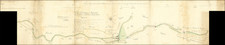
Eastern (left) half only of this important Omaha Beach map and panorama combination, which was prepared in the immediate lead-up to the Allied landings on D-Day to assist troops in orienting themselves with the landmarks of their assigned landing sectors.
The views cover sections of Omaha Beach between Ste. Honorine des Pertes and St. Laurent-Sur-Mer. Colleville-Sur-Mer and Les Moulins are shown in the lower, more zoomed-out, section. These roughly correspond with the Fox Green and Easy Red sectors of Omaha Beach.
The Omaha landings at Fox Green and Easy Red sectors on D-Day, June 6, 1944, were pivotal moments in the Allied invasion of Nazi-occupied France during World War II. These sectors, part of the broader Omaha Beach assault, witnessed intense and brutal combat as American forces faced daunting obstacles. The geography of Omaha Beach, with its high cliffs and strong German fortifications, posed significant challenges. The initial waves of soldiers, largely from the 1st and 29th Infantry Divisions, encountered fierce resistance from German troops who were well-entrenched in bunkers and armed with machine guns and artillery. Despite suffering heavy casualties, the bravery and resilience of the American soldiers were instrumental in overcoming the defenses, enabling further inland advances and setting the stage for the liberation of Europe from Nazi control.
The imprint line "25/26/4/44/668/107" would seem to indicate that this was printed in April of 1944.
While certainly prepared for American forces, we are unsure who was directly responsible for the production of this panorama.
We have only found a well-worn example on a militaria forum comment over 10 years ago.

![(Napoleon III) Camp De Chalons - Sur - Marne / Plan du Terrain Affecte au Camp et Des Terrains Environnans Leve par les Officieres du Genie Paris 1857 [with military movements added by hand]](https://storage.googleapis.com/raremaps/img/small/65093op.jpg)
![(Second World War - First Soviet Breakthrough into Germany) Генеральный Штаб Красной Армии - (Фюрстенвальде) | (Франкфурт) [General Staff of the Red Army - (Fürstenwalde) | (Frankfurt)]](https://storage.googleapis.com/raremaps/img/small/63108.jpg)
![[Douai] Duacum, Catuarcorum urbs tam situ, quam incolis, et litterarum studijs elegantissime ornata](https://storage.googleapis.com/raremaps/img/small/55817mp2.jpg)