|
||

|

|
|

|
May 1944 Pre-D-Day Reconnaissance Overprint Edition
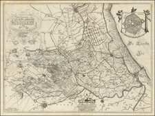
This pair of charts of the Normandy coast, covering much of Omaha and Utah Beaches, was prepared in May 1944 in preparation for the D-Day landings the following month.
The "Reconnaissance Overprint" editions of these maps contrast with the "Defences" overprint editions, which carried the higher classification rating of "Top Secret" and showed more military information. The Recon maps focus on the traversability of roads and terrain and give away less in the way of specific information about Germany troop emplacements as understood by the Allies.
The map extends from the famous Les Moulins beach exit, just east of Vierville-Sur-Mer, through the western end of Omaha Beach, the famous U.S. Army Ranger battlefield of La Pointe du Hoc (here, erroneously, "Pointe du Hoe", as often during this time), across La Baie des Veys (Bancs du Grand Vey), to the southern section of Utah Beach.
The maps indicate they were compiled from aerial photographs taken on a control provided by existing French triangulation.
The backs of the maps have detailed keys relating what symbols indicate what kinds of guns were in place at the German defenses, etc.
In June of 1944, fierce combat occurred in the areas spanning from the Les Moulins beach exit, located just east of Vierville-Sur-Mer, to the southern section of Utah Beach. The combat was waged by the U.S. Army and its allies against the German forces, as part of the larger Normandy landings that marked a turning point in World War II.
The map of the combat zone includes several strategic locations that witnessed intense fighting. One of these is the western end of Omaha Beach, which was one of the primary landing sites for the U.S. forces. Despite facing heavy resistance from the German defenders, the U.S. troops managed to establish a foothold on the beach and eventually gain control of the surrounding areas.
Another key location in the combat zone was La Pointe du Hoc, also known as "Pointe du Hoe" during this time. This was a U.S. Army Ranger battlefield that required the troops to scale a 100-foot cliff while under heavy fire from the German defenders. Despite the odds, the Rangers were able to successfully take control of the area and neutralize several key German positions.
Finally, the southern section of Utah Beach was another critical location that witnessed significant combat during the Normandy landings.

![(Second World War - The Aftermath - Abdication of Leopold III) En Pleine Guerre! Voici le Domaine dont Leopold III Revendiquait les Titres: Saxe-Cobourg-Gotha. . . [In the middle of a war! Here is the region where Leopold III Claimed Title: Saxony, Coburg, Gotha. . .]](https://storage.googleapis.com/raremaps/img/small/91010.jpg)