|
||

|

|
|

|
Combining Archaeology and Geography To Analyze Pre-Columbian Oaxacan Culture
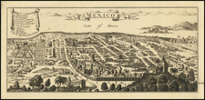
Detailed map of the area around the famed Oaxacan Archaeological site at San Pablo de Mitla, showing the area at the beginning of a period when it was being studied by a number of important Archaeologists, including Elsie Clews Parsons and Alfonso Canso.
The map notes the location of pre-Columbian ruins amidst the surviving landscape in the town of San Pablo de Mitla. Interestingly, it also includes a printed errata on the map, correcting a number of spelling errors.
Labeled Schmeider Map No. 4, the map seems to be the work of Oskar Schmeider, a German cultural geographer who worked in the region during the 1920s. and was likely issued to accompany his The Settlements of the Tzapotec and Mije Indians of Oaxaca, Mexico [with a map], University of California Publications in Geography, vol. 4. (Berkeley, 1930).
Oskar Schmieder's work in Mitla in the 1920s was part of his broader academic focus on the regional geography of Latin America. Mitla, an archaeological site in Mexico known for its pre-Columbian Mesoamerican architecture, would have offered Schmieder a unique case study in his research.
His approach in Mitla would have been grounded in analyzing the interaction between the area's geographical characteristics and its historical and cultural development. This perspective aligns with the cultural-genetic method, which emphasizes understanding landscapes through both their physical features and the influence of social and historical factors.
In Mitla, Schmieder's research likely involved examining the relationship between the site's geographic setting, such as its location in a valley and its climate, and the architectural and cultural achievements of the indigenous Zapotec and Mixtec civilizations. This would include studying the site's well-known architectural features, like the intricate geometric designs, and considering how these might have been influenced by the natural environment.
Schmieder's time in Mitla would have been a component of his wider interest in Latin America, contributing to his academic work and later teachings. His observations and findings in Mitla would have provided valuable insights into the complex interplay of geography and culture in this region, thus enriching his overall contributions to the field of geography, particularly in the context of his association with the University of California at Berkeley and the development of the Berkeley School of Geography's Latin American focus.
San Pablo de Mitla
San Pablo de Mitla, hosts the second-most important archaeological site in Oaxaca, Mexico, and the paramount site of the Zapotec culture. The history of the site spans several millennia. Located about 25 miles from Oaxaca City in the Tlacolula Valley, Mitla's archaeological significance is deeply intertwined with the cultural narratives of the Zapotec and Mixtec civilizations.
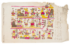
Early History and Zapotec Influence: Mitla, known as "Lyobaa" (place of rest) in Zapotec and translated to "Mictlán" (place of the dead) in Nahuatl, was primarily a sacred burial site for the Zapotec. Its intricate mosaic fretwork and geometric designs, unique in Mesoamerican sites, display a remarkable level of craftsmanship, with finely cut stones assembled without mortar. The site's architecture and design show significant Mixtec influence, particularly during their dominance in the region.
Archaeological Evolution: Inhabited since at least the Classic Period (100-650 CE) and possibly as early as 900 BCE, Mitla evolved from a fortified village to the principal religious center of the Zapotec culture. The Mixtec took control around 1000 CE, but the site remained populated largely by Zapotec, reaching its zenith between 750 and 1521 CE, during which it exhibited a fusion of Zapotec and Mixtec architectural styles.
Mitla symbolized the Mesoamerican belief in the afterlife, serving as a bridge between the living and the dead. This significance continued even as the Spanish arrived in the 1520s, with Mitla functioning as a major religious hub. The site covered an extensive urban area, supported by advanced agricultural practices in the surrounding rural regions.
Spanish Influence and Destruction: The early colonial period saw some of the first descriptions of Mitla by Spanish invaders and missionaries. Notably, Friar Toribio de Benavente Motolina and Diego García de Palacio provided early accounts in the mid-16th century. However, in 1553, the Archbishop of Oaxaca ordered the destruction of the Mitlan site, significantly damaging the structures. The Spaniards reused the stone blocks for building churches, including the Church of San Pablo, constructed atop part of the ruins.
20th Century Excavations and Studies: Mitla gained prominence during the government of Porfirio Díaz in the early 20th century, especially during the Centennial celebrations of Mexico’s Independence. Notable archaeologists like Alfonso Caso, who excavated Monte Albán, also conducted significant studies at Mitla in the 1920s and 1930s. These excavations revealed further details about the site's layout, construction techniques, and cultural significance.
From 1929 to 1933, the anthropologist Elsie Clews Parsons spent time in Mitla. Her visits were timed not only with the area’s destructive earthquake of 1931, but also with an era of relatively rapid change as new railroad and road connections between Mexico City and the Valley of Oaxaca introduced new technologies and products to the village dwellers of the region. Parsons published her studies of local life ways and folklore, Mitla: Town of Souls, in 1936.
Rarity
The separate map is quite rare, as is Schmeider's text.
OCLC locates only the example at the Bancroft Library (UC Berkeley).
Oskar Schmieder, born on January 27, 1891, in Bonn, Germany, and passing away on February 12, 1980, in Schleswig, was a distinguished German geographer recognized for his expertise in the regional geography of Latin America. His formative years in academia were spent at the University of California at Berkeley, working alongside Carl O. Sauer. There, he held the position of Associate Professor from 1926 to 1930.
Schmieder's academic journey in geography took him through the University of Bonn, the University of Königsberg, and the University of Heidelberg. His doctoral thesis on the Sierra de Gredos was guided by Alfred Hettner. It was here that he began integrating the physical geography with an understanding of social and cultural-historical elements that shape landscapes, a concept later termed the cultural-genetic method, influenced by Hettner's teachings. His first expedition to Peru in 1914 marked a turning point, though it was interrupted by his participation in the First World War.
After completing his Habilitation under Alfred Philippson in 1919 with a focus on the settlement geography of Ávila in Spain, Schmieder returned to Latin America. Prior to his tenure in Peru and Chile, he served as a professor of mineralogy and geology at the Universidad Nacional de Córdoba, Argentina, from 1920 to 1925. His regional expertise was later recognized at the University of California at Berkeley, where he collaborated with Carl O. Sauer, contributing significantly to the Latin Americanist perspective and possibly introducing German geographic methodologies to the Berkeley School of Geography. His tenure included extensive research with Sauer in Baja California and teaching courses in Latin American regional geography, which influenced many students including Fred B. Kniffen, Samuel N. Dicken, and Julian Steward. Despite an offer for a full professorship from Sauer, Schmieder returned to Germany in 1930.
Upon his return, Schmieder assumed a professorial role at the University of Kiel, continuing his focus on Latin American geography with his disciple Herbert Wilhelmy. During this period, he aligned with the prevailing nationalist and national socialist ideologies, becoming a proponent of Fascist Italy's colonial policies and joining the NSDAP in 1941. He notably advocated for a large-scale population transfer between South America and Africa, reflecting the national socialist views of the time.
Schmieder's later career saw him at the University of Halle before returning to Kiel. In the 1950s, he was a visiting professor at the University of Karachi and the University of Chile. He was recognized in a 1967 edition of the Pakistan Geographical Review as a seminal figure in German geography, echoing the influences of Hettner and as an integral part of the Berkeley School of Geography. His commitment to Länderkunde, a regional geography approach, was a defining aspect of his scholarly work.
![[Manuscript Map of Land Dispute in Veracruz]](https://storage.googleapis.com/raremaps/img/small/55847.jpg)
![[Mexico City and Environs] Mapa de las Lagunas, Rios y Lugares que Circundan a Mexico: para mayor inteligencia de la Historia y Conquista de Mexico que escribió Solis . . . 1783](https://storage.googleapis.com/raremaps/img/small/91029.jpg)
![A Map of British Honduras... [bound in:] Tratado de Limites Entre Los Estados-Unidos Mexicanos y Honduras Britanica Seguido de los principales documentos que a el se refieren. Edicion Oficial.](https://storage.googleapis.com/raremaps/img/small/70984.jpg)