


|
||

|

|
|

|
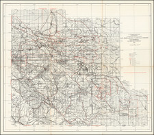
Rare geological map of the Iowa Hill Mining District of Placer County, published in Sacramento by the California State Mining Bureau, the map identifies J.B. Hobson, assistant in the field as the creator of the image.
The Iowa Hill Mining District is located in Placer County, California. In 1853, miners prospecting the North Fork of the American River discovered gold along the north flank of a ridge between the North Fork of the American River and Indian Canyon. The miners made camp atop the ridge and christened it Iowa Hill and from then on the ridge became known as the Iowa Hill Divide. Further prospecting revealed that the rich Tertiary gravel deposits were perched above the American River on the flanks and underlying the divide. The camp grew around the Jamison claim, which was first drift mined and later hydraulically mined.
The geological map of the Iowa Hill Mining District in Placer Countywas reated by the California State Mining Bureau in about 1890, during a boom period in Hydraulic Mining in the region. The map puts a geological overview of the regions geography and mining claims, noting>
-
Overlying Volcanic Capping - Represented by a plain pink color, indicating the surface layer composed of volcanic rock that has covered other geological formations.
-
Mixed Gravel, Hydraulic Ground - Shown with a yellow color and a texture that resembles hatching, symbolizing areas that have been subjected to hydraulic mining processes.
-
Hydraulic Banks - Depicted as black zigzag lines on a yellow background, these are specific locations within the hydraulic ground where mining activities have formed steep banks.
-
Hydraulic Pits, Worked out. Rock exposed - Illustrated with a solid gray color, these are the pits left behind after hydraulic mining, where the original rock is now exposed due to the removal of overburden and gravel.
-
Contact between Underlying Rock & Drift Deposit - A black dashed line represents the boundary between the bedrock below and the deposits of sediment above.
-
Underlying Metamorphic Rock. Slate, Chlorite, Talc, and Mica Schists. Occasional Dykes of Diorite - A light gray color indicates the presence of metamorphic rocks beneath the surface, which could include slate, chlorite, talc, mica schists, and sometimes diorite, which is an intrusive igneous rock.
-
Ancient River Channels:
- Blue Gravel Channels - Shown with blue hatching, these channels are old river beds filled with gravel, which are often rich in placer gold deposits.
- Golden Gate Channel - Identified by green hatching, is a specific named channel within the district known for its deposits.
- Channels Eroded during Volcanic Period - Represented by diagonal hatching, indicating channels formed or altered by volcanic activity.
- Channels Worked out by Drifting - A pattern of horizontal lines and dots symbolizes ancient river channels that have been mined by the method of drifting.
- Direction of Flow of Ancient Stream - A series of arrow-like symbols shows the flow direction of water in these ancient stream channels.
-
Tunnels - Depicted with a solid line with breaks, these symbols mark the locations of tunnels.
-
Roads - Shown as three parallel lines, these indicate the roads used for transportation and access within the mining district.
-
Trails - A single sinuous line represents paths or trails in the area.
The importance and usage of these symbols on the map are crucial for understanding the geological composition, mining history, and topography of the area and were used by miners and geologists to locate potential mining sites, understand the landscape's history, and navigate the region during mining operations.
Iowa Hill / Iowa City, California
As noted above , gold was first discovered in the area by a group of miners from Iowa in 1853.
First named "Iowa City", the post office was first opened in 1854. By 1856, the production value of the mines exceeded $100,000. By 1880, the production value was up to $20 million.
During the first few years drift mining prevailed, with many miles of drifts being driven under the divide to exploit the rich blue lead gravels. The North Star Mine was the first in the state to use a stamp mill to crush the hard cemented basal blue-lead gravels. When these gravels began to play out, attention turned to hydraulic mining of the finer gravels along the flanks of the divide.
The introduction of water by the Iowa Hill Canal rendered the working of large tracts of land quite profitable. In 1875, there was enough traffic to support two daily lines of stages connecting with the railroad at Colfax.
The region would become one of the significant hydraulic mining areas in the state. Some of the short-lived camps in the area included Independence Hill, Roach Hill, Bird’s Flat, Stephen’s Hill, Elizabethtown, Wisconsin Hill, Grizzly Flat at Grizzly Canyon, and Montana Flat. Drift mining continued through the early 1900s, and there was appreciable activity again in the 1930s. Most of the town was destroyed by fire in 1922
Hydraulic mining, which became prevalent in the 1850s and 1860s, was a form of mining that used high-pressure jets of water to dislodge rock material or move sediment. In the placer mining method, these high-pressure water cannons could wash away entire mountainsides, which would then be run through sluices to extract the gold.
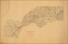
The cross-section plates accompanying the geological map of the Iowa Hill Mining District would have been essential for the miners and geologists of the time. These drawings provided detailed insights into the geological strata of the area, including ancient river channels that were often rich with gold deposits, known as 'blue' and 'white' gravel channels due to the color of the gravel they contained. These channels, once riverbeds, had been buried and preserved under volcanic material, known as 'volcanic cappings' in the reference key, and were sought after for the potential wealth they contained.
The method of hydraulic mining, illustrated in these plates by the presence of various channels and diggings, was later restricted by the federal government with the passage of the Sawyer Decision in 1884 due to the massive environmental degradation it caused.
The Iowa Hill district was known for its rich deposits and was one of the most productive in the state. However, the nature of its hydraulic mining operations meant that the landscape underwent a dramatic transformation, with hillsides washed away and valleys filled with debris. These cross-sections serve not only as technical documents for mining operations but also as historical records of the extensive impact human activity had on California's natural landscape during the Gold Rush.
Rarity
This is one of 3 separately published maps and diagrams to accompany the 10th Report of the California State Mining Bureau.
OCLC locates 4 examples (Yale, University of Chicago, UC Berkeley, UC Riverside).
![[ One of the First Printed Views of California ] A Remarkable Mountain near the River of Monterrey](https://storage.googleapis.com/raremaps/img/small/88071.jpg)

![[Los Angeles & Orange Counties] Status of Lands Survey Conducted During 1926 Central Portion of Coastal Plain . . .](https://storage.googleapis.com/raremaps/img/small/66323.jpg)