This item has been sold, but you can enter your email address to be notified if another example becomes available.


|
||

|

|
|

|
Stock# 0792
Description
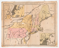
Marvelous example of Tanner's map, with insets of Hartford and New Haven. The map is hand colored by counties, and shows towns, roads with distances, steam and stage routes, railroads, canals, and a host of other details. Statistical tables provides populations by counties and historical information dating back to 1701. Tanner's maps rarely appears on the market. A nice wide margined example.

![[ New England and Great Britain ] Nova Anglia Gaudenbonis Plurimis De Est Tame Adhuc Angelorum Regin [and] M[ag]na Britannia Dei Matri Cuitu & Beneficiis olim hodieque celebrata](https://storage.googleapis.com/raremaps/img/small/95667.jpg)