This item has been sold, but you can enter your email address to be notified if another example becomes available.


|
||

|

|
|

|
Stock# 0665
Description
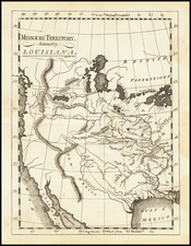
Fascinating map of the Southwest, at the time of Mexico's independence. California is dominated by pre-Fremont Cartographic features, including a mythical river extending toward Salt Lake. Lake Teguayo is shown, along with an are marked Freye Indianer. Dozens of notes on Indians throughout California, Arizona, Utah, Nevada and Colorado. Excellent details in the Rocky Mountains, based upon Humboldt, Pike and Fremont. Texas is named, but the map shortly predates Austin's Colony. Remarkably, Wheat overlooks this map entirely, although he does note the 1834 United States map. Remarkable early map of the southwest.
![[Report and] Map of an Exploring Expedition to The Rocky Mountains in the Years 1842 and to Oregon & North California in the Years 1843-44 By Brevet Capt. J. C. Fremont of the Corps of Topographical Engineers . . .](https://storage.googleapis.com/raremaps/img/small/88488.jpg)
![(Texas Itineraries for the Mexican Northern Army) Coleccion de Itinerarios Para Diferentes Puntos de la Republica Mexicana, Formados Por la Seccion de Geografia y Estadistica de la Plana Mayor del Ejercito, Mandada Imprimir por Orden del Supremo Gobierno de 14 de Marzo de 1844 [including:] Itinerario Razonado de la Ciudad de S. Luis Potosí al Rio Sabina por el Saltillo](https://storage.googleapis.com/raremaps/img/small/94663.jpg)
![[Sonoma] Hyde Ranch](https://storage.googleapis.com/raremaps/img/small/66631.jpg)