


|
||

|

|
|

|
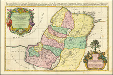
Striking large and highly detailed map of the Holy Land, illustrating the 12 Tribes of Israel and other Biblical information. Two large attractive cartouches. Dated 1691. A bit of soiling at the centerfold, but overall a nice example. A fine decorative example with wide clean margins. Perhaps the largest of all Holy Land maps to appear in a commercial atlas. From Jaillot's monumental atlas.
Alexis-Hubert Jaillot (ca. 1632-1712) was one of the most important French cartographers of the seventeenth century. Jaillot traveled to Paris with his brother, Simon, in 1657, hoping to take advantage of Louis XIV's call to the artists and scientists of France to settle and work in Paris. Originally a sculptor, he married the daughter of Nicholas Berey, Jeanne Berey, in 1664, and went into partnership with Nicholas Sanson's sons. Beginning in 1669, he re-engraved and often enlarged many of Sanson's maps, filling in the gap left by the destruction of the Blaeu's printing establishment in 1672.
![[ Maccabee Tomb ] Grafgebouw Der Makkabeen Opgeregt Te Modin](https://storage.googleapis.com/raremaps/img/small/101602.jpg)
![De Schepping der Wereldt Volgens de Beschryving van Mozes. 1 Plaat [in set with] De Schepping der Wereldt Volgens de Beschryving van Mozes. 2. Plaat](https://storage.googleapis.com/raremaps/img/small/102641.jpg)
![[Heightened with Gold Leaf! -- Paul's Travels ] De Reysen Christi Des Heyland en Pauli met andere syne Bloedgetuygen](https://storage.googleapis.com/raremaps/img/small/72900.jpg)