This item has been sold, but you can enter your email address to be notified if another example becomes available.


|
||

|

|
|

|
Stock# 0578
Description
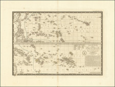
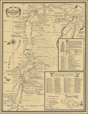
Rare map of the Hawaiian Islands and islands to the west, including I. Cure, I. Massachusetts and Rocher de la Perle et Hermes, from Dumont D'Urville's seminal voyage to the Pacific. This example of the map was apparently originally sold in a shop in La Havre (T. Cochard, Librarie), which sold nautical maps, and includes fascinating marginal notes on Mowee (Maui), including an outline map, place names and notes on honowaura and the village of Makena and environs, which suggest that the notes wer written in June 1851. Printed on very heavy paper. Fold split enters image by about 4 inches. A nice example of a working chart used by a contemporary of Dumont D'Urville. Worthy of the research to determine who was exploring Maui in June 1851!
![[Hawaii / Western Pacific]](https://storage.googleapis.com/raremaps/img/small/73805.jpg)