|
||

|

|
|

|
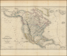
Striking map of North America prior to the Gadsden Purchase. Alaska is Russian America. Oregon Territory extends to the Canadian Border and the Rocky Mountains. Utah and New Mexico each extend from California to the Rockies and Beyond. Texas is badly misshapen on its western border. Predates the appearance of the massive Nebraska Territory, here simply called Northwest Territory. Very unusual Indian Territory configuration. Following Texas' annexation into the US and the Mexican War, the territorial boundaries of the west were in a state of rapid transition. This transition was at its most chaotic and inaccurate period cartographically between 1850 and 1856, when the borders of the various Territories was still the subject of great debate and misinformation, especially in Europe. During this time period, most of the most unusual and short lived territorial configurations and misconfigurations appear. It is quite literally impossible to note and explain each of the variants and for this reason, maps showing the American west prior to 1860 are an endless source of collector's intrigue. This folding map apparently accompanied Mr. Alcide D'Arbigny's book on America and did not appear in an atlas.