


|
||

|

|
|

|
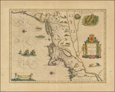
An important early map of the Northeast coast of America, centered on Cape Cod and Long Island. Based upon the 1614 manuscript map of Dutch fur trader Adriaen Block. One of the earliest to name Neu Amsterdam and Manhattan. Cape Cod is improved from Block's map and is no longer an island. The source of the Delaware and the Hudson are separated. The map includes deer, foxes, bears, egrets, rabbits, cranes and turkeys, along with Indian dugout canoes and sailing ships. The Mohawk village in the upper right is drawn from DeBry and White. A stunning wide margin copy of one of the most influential maps of the Northeast during the 17th Century. Burden 241.
Willem Janszoon Blaeu (1571-1638) was a prominent Dutch geographer and publisher. Born the son of a herring merchant, Blaeu chose not fish but mathematics and astronomy for his focus. He studied with the famous Danish astronomer Tycho Brahe, with whom he honed his instrument and globe making skills. Blaeu set up shop in Amsterdam, where he sold instruments and globes, published maps, and edited the works of intellectuals like Descartes and Hugo Grotius. In 1635, he released his atlas, Theatrum Orbis Terrarum, sive, Atlas novus.
Willem died in 1638. He had two sons, Cornelis (1610-1648) and Joan (1596-1673). Joan trained as a lawyer, but joined his father’s business rather than practice. After his father’s death, the brothers took over their father’s shop and Joan took on his work as hydrographer to the Dutch East India Company. Later in life, Joan would modify and greatly expand his father’s Atlas novus, eventually releasing his masterpiece, the Atlas maior, between 1662 and 1672.

![[ Temperance Allegorical View ] Black Valley Railroad. Tickets Sold at all Liquor Shops. Accidents by Collisions are Entirely Avoided, as no up Trains are Run Over the Road.](https://storage.googleapis.com/raremaps/img/small/101469.jpg)


![[ New England / Northeast / Canada ] Tierra Nueva](https://storage.googleapis.com/raremaps/img/small/86737.jpg)