|
||

|

|
|

|
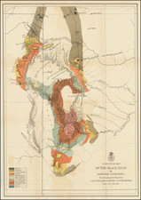
Detailed map of Colorado, one of the earliest published outside the United States. Based largely upon the GLO maps issued in 1865 and 1866. The map and another map of the United States (13.5x7 inches) are bound into this rare exposition pamphlet, likely a promotional piece circulated in Paris during the 1867 Exposition. The work would appear to have been translated from an equally rare English edition, published in the same year (Howes 387). This edition is unrecorded and neither edition appears in Phillips. We have had the maps from this edition once before, which had been bound into an 1865 Colton Octavo Atlas of the World, along with several other maps, illustrating the owner's trip from NYC to Colorado. A rare pamphlet in fine condition.
![Mexico [Texas on the Eve of Independence]](https://storage.googleapis.com/raremaps/img/small/84917.jpg)
![(Humboldt Atlas and Text) Geographique et Physique du Royaume de Nouvelle-Espagne [with quarto text:] Essai Politique de la Royaume de la Nouvelle-Espagne](https://storage.googleapis.com/raremaps/img/small/99796.jpg)