|
||

|

|
|

|
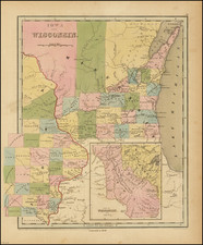
Stock# 0292
Description
Detailed and interesting map, hand colored by county and showing towns, rivers, bays, lakes, railroads, roads, distances, etc. Tables of Steam Boat routes and distances. A nice example of this increasing difficult to obtain map, from Thomas Cowperthwait version of Mitchell's Universal Atlas. A number of Michigan Counties still not yet formed. Railroads are shown in Red and Canals in Blue. An unsually clean fresh example.


![[ Mississippi River Atlas ] Theorie der Bewegung des Wassers in Flüssen und Canälen. . . . (Atlas Volume)](https://storage.googleapis.com/raremaps/img/small/101700.jpg)