|
||

|

|
|

|
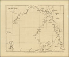
Rare German language edition of Cook's chart showing information drawn from, Carteret, Cook and Dampier's explorations along the coastlines of Papua New Guinea and New Britain, the largest island in the Bismarck Archipelago northwest of New Guinea, from the official account of Captain James Cook's first expedition to the Pacific Ocean.
Translation of the title is: Map of the discoveries of Captain Cartaret in New Britain together with the passage of Captain Cook crossing the Endeavour Straits and the discoveries of Captain Dampier in New Guinea and New Britain in 1699 and 1700.
The map provides one of the most detailed and up to date treatments of the region, integrating the discoveries of the 3 major explorations into the region over the prior 75 years.