
The item illustrated and described below is sold, but we
have another example in stock. To view the example which
is currently being offered for sale, click the
"View Details" button below.


|
||

|

|
|

|
Stock# 0217gh
Description
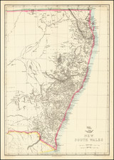
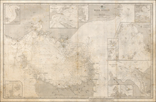
Highly detailed map of New South Wales, from the Weekly Dispatch Atlas.
Includes nice early detail in the interior of NSW and fine detail along the coas.
'The Weekly Dispatch' newspaper between the years 1856 and 1862 included in each edition a map of a part of the world. During this period a total of 118 maps were issued. The maps bear the distinctive sign of a half globe with the figure of Mercury above. The engravers varied but included John Dower and Edward Weller.
In 1863 ' The Dispatch Atlas' was published which contained a series of English county maps. The two were combined in 1865 as 'Cassell's Complete Atlas'. With many maps in a large scale of areas not often seen, including a number a town plans.
![[ Australia called Notasie ou Nouvelle Hollande ] Carte De L'Oceanie Contenant L'Australe, La Polynesie et Les Iles Asiatique . . . 1838](https://storage.googleapis.com/raremaps/img/small/99649.jpg)
![Representation du Cours ordinaire des Vents de Traverse qui regnent les Cotes dans la grande Mer Du Sud [California as an Island]](https://storage.googleapis.com/raremaps/img/small/54744.jpg)