


|
||

|

|
|

|
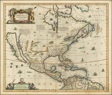
A nice example of the late 17th or early 18th Century Italian reproduction of Jansson's map of North America. The most obvious source of the the hoax is the attribution in the lower cartouche to Henricum Hondium Anno 1631, 2 years after Hondius' death. On close inspection, the map is clearly a different engraving than the map first engraved by Jansson in 1636. Burden refers to the map as one of the most important early maps of North America, drawing heavily from Briggs map of 1626. An unnamed lake still feeds a Rio de Norto flowing southwest into the Sea of Cortez. The Gulf of Mexico and Florida are based upon Hessel Gerritsz map of 1631. The east coast draws from a number of sources. Jamestown is shown. Novum Belgium is unlike prior maps between the Delaware and Hudson, being greatly elongated. New Amsterdam is not shown, but Ft. Orange is located. The placenames in New England are based upon John Smith's map of 1616. The Gulf of St. Lawrence appears to follow De Laet. The map is richly decoratied with ships, sea monsters and animals in the interior parts of North America. The reason for the reproduction is unknown, but the map often sparks a lively debate among those who would wish it to pre-date the 1636 edition. Laid down on a heavy board, else a nice example. A gorgeous late 17th Century image--with a marvelous history of intrigue and deceit!
Jan Janssonius (also known as Johann or Jan Jansson or Janszoon) (1588-1664) was a renowned geographer and publisher of the seventeenth century, when the Dutch dominated map publishing in Europe. Born in Arnhem, Jan was first exposed to the trade via his father, who was also a bookseller and publisher. In 1612, Jan married the daughter of Jodocus Hondius, who was also a prominent mapmaker and seller. Jonssonius’ first maps date from 1616.
In the 1630s, Janssonius worked with his brother-in-law, Henricus Hondius. Their most successful venture was to reissue the Mercator-Hondius atlas. Jodocus Hondius had acquired the plates to the Mercator atlas, first published in 1595, and added 36 additional maps. After Hondius died in 1612, Henricus took over publication; Janssonius joined the venture in 1633. Eventually, the atlas was renamed the Atlas Novus and then the Atlas Major, by which time it had expanded to eleven volumes. Janssonius is also well known for his volume of English county maps, published in 1646.
Janssonius died in Amsterdam in 1664. His son-in-law, Johannes van Waesbergen, took over his business. Eventually, many of Janssonius’ plates were sold to Gerard Valck and Pieter Schenk, who added their names and continued to reissue the maps.

![Central Valley Project -- California [Map and Views of California]](https://storage.googleapis.com/raremaps/img/small/91596.jpg)

![[The Final State] A New Map of North America, with the West India Islands, Divided according to the Preliminary Articles of Peace, Signed at Versailles, 20 Jan. 1783, wherein are Distinguished The United States and the Several Provinces, Governments &c Which Compose the British Dominions . . . 1794](https://storage.googleapis.com/raremaps/img/small/89085.jpg)