|
||

|

|
|

|
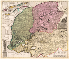
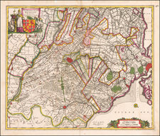
Old color, gold heightened example of Visscher's map of the 17 Provinces of the Netherlands.
Elaborately and beautifully decorated map of the XVII Provinces with the west on top. Decorative cartouche topped with a rampant lion with a sword. At the bottom of the cartouche there is the crest of Johan Munter. Munster was a wealthy merchant in Amsterdam whom held several posts of honour in Amsterdam. He became commissioner of the exchange bank, he was 'Schepen' [city councillor], was a member of the governing body of the V.O.C. and finally became major of the city.
The present example appeared in an Abraham Wolfgang composite atlas. The first state of Visscher's map was of this map published in 1672. The map was copied to the smallest detail by Frederik de Wit, Justus Danckerts, Bormeester, Gerard van Schagen, David Funcke, Covens & Mortier and John Seller.
De Wit (1629 ca.-1706) was a mapmaker and mapseller who was born in Gouda but who worked and died in Amsterdam. He moved to the city in 1648, where he opened a printing operation under the name of The Three Crabs; later, he changed the name of his shop to The White Chart. From the 1660s onward, he published atlases with a variety of maps; he is best known for these atlases and his Dutch town maps. After Frederik’s death in 1706, his wife Maria ran the shop for four years before selling it. Their son, Franciscus, was a stockfish merchant and had no interest in the map shop. At the auction to liquidate the de Wit stock, most of the plates went to Pieter Mortier, whose firm eventually became Covens & Mortier, one of the biggest cartography houses of the eighteenth century.
![[Holland and the Kingdom of Belgium or the Netherlands] L'Olanda e il Regno Belgico ovvero i Paesi Bassi](https://storage.googleapis.com/raremaps/img/small/82726.jpg)