|
||

|

|
|

|
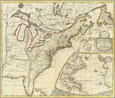
Goos's chart is the first sea chart to focus on the Delaware Valley, New Jersey and the environs of New York City.
Goos's chart of the area from Manhattan to the mouth of the Delaware River is the first printed chart to focus on New Jersey and the Delaware Valley, and was almost certainly issued separately, prior to 1666, a part of the Dutch efforts to colonize the region. The Dutch had established the colony of New Netherlands in 1624, but by 1638, Sweden had established a competing / encroaching settlement (in part with the help of an alienated Dutch settler), with the founding of Ft. Christina. In 1651. the Dutch established Ft. Kasimer on the Delaware to counter the Swedish claims. The issue was in dispute until Peter Styvesant's capture of Ft. Christina in 1655.
Goos' chart shows the Dutch settlements on the Delaware and their location relative to New Amsterdam. A number of early Dutch forts on the Delaware appear for the first time on printed maps. The environs of New Amsterdam are show on a larger scale than virtually any other earlier printed map and include a number of place names which appear for the first time, including Broncken (Bronx) and Rechkewach (Rockaway). Helles gat (Hells Gate) and Hooboocken are also shown among the 20 or so place names in and around New York Harbor.
As noted above, Goos' chart was almost certainly issued separately some time between 1655 (when the Dutch took control of the Delaware River Valley from Sweden) and 1664 (when the English first took control of New Amsterdam) to promote the settlement at Fort Casimir. However, no examples of the chart from this period are known to have survived. A few copies were bound into Goos' Zee-Atlas beginning in 1666, although Burden and others note that the addition of this map to the Zee-Atlas was almost certainly by special order only.
Because the chart is much larger than the other maps in this work, the the chart is almost invariably trimmed into the image, with loss of neat line top and bottom. A survey of the 26 editions or variants of the Zee-Atlas listed by Koemann shows that only 4 included the map. The present example, in fine original color, is only the second example we have handled in 20 years.
Pieter Goos (ca. 1616-1675) was a Dutch map and chart maker, whose father, Abraham Goos (approx. 1590-1643), had already published numerous globes, land and sea maps together with Jodocus Hondius and Johannes Janssonius in Antwerp. Pieter gained recognition due to the publication of sea charts. He bought the copperplates of the famous guide book for sailors, De Lichtende Columne ofte Zeespiegel (Amsterdam 1644, 1649, 1650), from Anthonie Jacobsz. Goos published his own editions of this work in various languages, while adding his own maps. In 1666, he published his De Zee-Atlas ofte Water-Wereld, which is considered one of the best sea atlases of its time. Goos' sea charts came to dominate the Dutch market until the 1670s, when the Van Keulen family came to prominence.
![[Revolutionary War Plans of New York, Boston, Charleston, Delaware River to Philadelphia & Havana] Various Plans and Draughts of Cities, Towns, Harbours &c . . .](https://storage.googleapis.com/raremaps/img/small/83450.jpg)