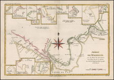
![America noviter delineata Auct. Judoco Hondio [Extremely rare 3 panel carte a figures state] By Jodocus Hondius / Jan Jansson](https://storage.googleapis.com/raremaps/img/small/66116.jpg)


|
||

|

|
|

|
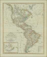
Rare map of America first issued by Jan Jansson in 1623 with 4 sets of decorative panels. The first edition of the map was issued separately and is known in only 1 example. This is the rare 3rd state of the map, first issued in 1632 w/o the lower panel. While at first blush the map appears similar to Blaeu's America, this example includes views of North America, including the Poeiock Village in North Carolina & views of Carolina and St. Augustine. The penninsular California is retained, with the extended Northwest Coast including definitive place names north of 40 degrees. The East Coast of North America is rich with Indian names. The polar region inset is derived from Blaeu's wall map of 1608, as are the towns illustrated along the top. All states of this map are very rare. The map is easily distinguished by the chip in the upper right corner, which first appears in the 4 panel 1630 edition. An attractive example in full color. Several expert restorations along the right side of the map, but in all, a visually stunning example of this great rarity. Burden 207. One of the most sought after of all Dutch maps of America.
Jan Janssonius (also known as Johann or Jan Jansson or Janszoon) (1588-1664) was a renowned geographer and publisher of the seventeenth century, when the Dutch dominated map publishing in Europe. Born in Arnhem, Jan was first exposed to the trade via his father, who was also a bookseller and publisher. In 1612, Jan married the daughter of Jodocus Hondius, who was also a prominent mapmaker and seller. Jonssonius’ first maps date from 1616.
In the 1630s, Janssonius worked with his brother-in-law, Henricus Hondius. Their most successful venture was to reissue the Mercator-Hondius atlas. Jodocus Hondius had acquired the plates to the Mercator atlas, first published in 1595, and added 36 additional maps. After Hondius died in 1612, Henricus took over publication; Janssonius joined the venture in 1633. Eventually, the atlas was renamed the Atlas Novus and then the Atlas Major, by which time it had expanded to eleven volumes. Janssonius is also well known for his volume of English county maps, published in 1646.
Janssonius died in Amsterdam in 1664. His son-in-law, Johannes van Waesbergen, took over his business. Eventually, many of Janssonius’ plates were sold to Gerard Valck and Pieter Schenk, who added their names and continued to reissue the maps.
![[Nova et Acurata Totius Americae Tabula auct. G.I. Blaeu] America quarta pars orbis quam plerunq, novum orbem appellitant) primo detccta est anno 1492, a Christophoro Columbo Genuensi auspicijs Regis Castiliae, Deutde ulterius perucistigata navigationibus Americi Florentini, de cuius nomine America dicta est circiter annum 1497 Verum anno 1520 Ferdiandus Magallanus primus fuit qui extremos limites ad austru vergentes navigatione per fretum de nomine suo Magallanicu dictu uisitauit et noto fecit](https://storage.googleapis.com/raremaps/img/small/81465.jpg)