This item has been sold, but you can enter your email address to be notified if another example becomes available.


|
||

|

|
|

|
Stock# 0048em
Description
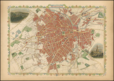
Incorporated into the border is a view of Beverley Minster.
Maps by Thomas Moule (1784-1851) are probably, with those by Speed, the best known of all series of English county maps. Issued from 1830 the maps combine a clarity of cartographic style with immense detail by way of vignette views, scenes and portraits relating to the county or town shown. The maps are often set within a gothic architectural or floral surround, into which armorial devices and so on are worked.
The 57 maps and plans produced for Moule's "English Counties Delineated" were originally issued as a part-work and remain as popular today as they were in the early years of Queen Victoria's reign.
Condition Description
toning and minor loss