


|
||

|

|
|

|
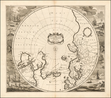
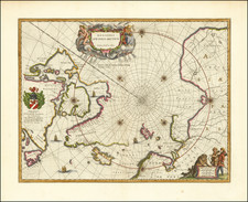
Nice example of the first edition of Blaeu's signature map of the North Polar Regions, with several wonderful cartouches and decorative coat of arms.
Blaeu's decorative map of the North Pole, including Arctic North America, Scandinavia, and northern Asia, was one of the longest enduring 17th Century polar maps. The information for this map is based on the discoveries of James, Barentsz, Baffin, Frobisher, Hall, Davis, and others. In particular, this map incorporates the discoveries of James along the southern and western shore of Hudson's Bay in 1631-32, and promotes the view that the famous "Northwest Passage" across northern North America did not exist.
The map's detail would suggest the existence of a north-east passage as the coastline appears in tact and the sea clear and without any barrier to progress. The Canadian Arctic waters, however, appear almost landlocked lacking any promise of a north-west route to the Indies.
The first edition of the map does not include a dedication cartouche at the center left, which was added in 1645, with the addition of the coats of arms of dedicatee Gulielmo Backer De Cornelis and the addition of Johannes Blaeu's name below the dedication.
Joan, or Johannes, Blaeu (1596-1673) was the son of Willem Janszoon Blaeu. He inherited his father’s meticulous and striking mapmaking style and continued the Blaeu workshop until it burned in 1672. Initially, Joan trained as a lawyer, but he decided to join his father’s business rather than practice.
After his father’s death in 1638, Joan and his brother, Cornelis, took over their father’s shop and Joan took on his work as hydrographer to the Dutch East India Company. Joan brought out many important works, including Nova et Accuratissima Terrarum Orbis Tabula, a world map to commemorate the Peace of Westphalia which brought news of Abel Tasman’s voyages in the Pacific to the attention of Europe. This map was used as a template for the world map set in the floor of the Amsterdam Town Hall, the Groote Burger-Zaal, in 1655.
Joan also modified and greatly expanded his father’s Atlas novus, first published in 1635. All the while, Joan was honing his own atlas. He published the Atlas maior between 1662 and 1672. It is one of the most sought-after atlases by collectors and institutions today due to the attention to the detail, quality, and beauty of the maps. He is also known for his town plans and wall maps of the continents. Joan’s productivity slammed to a halt in 1672, when a fire completely destroyed his workshop and stock. Joan died a year later and is buried in the Westerkerk in Amsterdam.