|
||

|

|
|

|
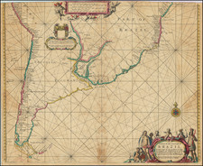
Extremely rare early sea chart by Arent Roggeveen, showing the area between the two rivers (Demara and Orinoco), the earliest printed sea chart to focus so closely the region.
The present map focuses on the area which would become Guiana. According to some authors Columbus discovered Guiana in 1498; others beleive Vasco Nunez first landed on the coast of Guiana in 1504. Still others attribute the discovery to Diego de Ordas, of Leon, in 1531. He was one of the captains of Cortez in the conquest of Mexico.
Sir Walter Raleigh ascended the Orinoco in 1595, and Hakluyt, mentions already the rivers Curitini (Corentyn), Berbice, Wapari (Abari), Maicawini (Mahaiconi), Mahawaica (Mahaica), Lemerare (Demerara), Devoritia or Dessekebe (Essequibo), Matoreeni (Mazaruni), Cuwini, (Cuyuni), Pawrooma (Pomeroon), Moruga (Morucca), Waini (Guainia), Barima, etc. as the most considerable between the Corentyn and Orinoco. The earliest accounts which we have relative to the settlement of this coast, state that in 1580 some inhabitants of Zealand, one of the provinces of the Netherlands, sent out vessels to cruize on the Amazon, and westward to the Orinoco, in quest of discoveries. They formed a settlement near the river Pomeroon, which they called Nieuw Zealand, and another at the Labari or Wapari, now Abari river, where there was an Indian village called Nibie.
. In 1613 the colony of Zealanders at the banks of the Essequibo was reported to be in a flourishing condition ; and eight years afterwards, namely in 1621, the government undertook to supply the colonists with negro slaves from Africa. In 1626, van Peere, who with his companions had been driven from the Orinoco, commenced to settle at the banks of the river Berbice, and cleared a considerable extent of land between the Berbice and Corentyn rivers. In 1634, thirty passengers from West Friesland arrived at the island Mecoria between the rivers Cayenne and Wya, who settled and commenced cultivating tobacco and cotton. They found here some settlers from the Netherlands, and discovered on a rising ground the ruins of a French castle, which they repaired for their own protection. The English had commenced colonization about the same time at the great Coma, now Surinam river, sixty miles up, having been expelled from the little Coma, the present Comowini, by the Caribi Indians. They rebuilt here a large Indian village called Paramaribo, which had been destroyed by the natives at their approach. This village was commanded by Captain Marshall, with about sixty settlers ; but being constantly annoyed by the natives, and the climate proving unhealthy, they abandoned it afterwards.
About 1640 the French took control of the pesent river Surinam, and inhabited Paramaribo, although they quit the area quickly. The English returned in 1652 to Paramaribo, and the Caribi Indians having removed from Wanica to the Coponam, they were more successful in forming a settlement.
In 1662 the whole colony was granted by Charles II to Lrd Willoughby, the then governor of Barbadoes, who named the principal river, wherein Paramaribo is situated, Surryham, in honor of the Earl of Surry ; from which the whole colony took its name. The British Crown bought afterwards this colony from the heirs of Lord-Willoughby, and exchanged it with the Dutch government in 1667 for New Holland, in North America, the present New York.
In 1657 the rivers Pomeroon and Morocco were settled anew by Zealanders, and the towns of New Zealand and New Middleburgh were erected on their banks. The settlements on the Essequibo were taken in 1665 by the English, and afterwards plundered by the French, who destroyed the settlements on the Pomeroon. The same year a small English vessel of war sailed up the river Berbice, and attempted an attack of Fort Nassau, but was repulsed.
In 1669 the colony of Dutch Guiana, which then extended from the river Sinamari to the mouth of the Barima, which has its outflow in the Orinoco, was transferred from certain gentlemen owners in the towns of Amsterdam, Middleburgh, Flushing, and Veere, to the West India Company of Zealand.
Arent Roggeveen was a land surveyor, mathematician, poet and teacher of navigation. Born in Delfshaven, he later moved to Middelburg where both the Dutch East and West India Companies were based. He was employed by both companies as a teacher in the art of navigation. He also helped maintain their collections of hydrographic manuscripts and charts, including Spanish portulanos of the West Indies. In the mid 1660s, Roggeveen compiled a series of large scale charts of the North American coast line, West Indies and later, West Africa. His Het Brandende Veen or The Burning Fen represented a landmark in the coastal charting of North America, with a number of regions mapped in larger scale than in any previously printed work. Roggeveen arranged for Pieter Goos, one of the leading engravers and publishers of maritime books in Amsterdam to publish the collection. The completed work was the first Dutch pilot that was focused on select areas of the American coastline. Previously, all printed maps and charts that dealt with this coastline were on a much larger scale.
Roggeveen died in 1679. Goos' widow sold the plates to Jacob Robijn, who reissued the maps with his name added to the title, but otherwise unchanged, in 1680. Both examples of the map are extremely rare. The atlases were undoubtedly published in limited quantity. Working sea charts and pilots from the 17th Century are inherently rare due to the nature of their use aboard ships. The vast majority of them were either destroyed by use or destroyed intentionally when new updated versions were obtained.
Arent Roggeveen was a land surveyor, mathematician, poet and teacher of navigation. Born in Delfshaven, he later moved to Middelburg where both the Dutch East and West India Companies were based. He was employed by both companies as a teacher in the art of navigation. He also helped maintain their collections of hydrographic manuscripts and charts, including Spanish portulanos of the West Indies. In the mid-1660s, Roggeveen compiled a series of large scale charts of the North American coastline, West Indies and later, West Africa. His Het Brandende Veen or The Burning Fen represented a landmark in the coastal charting of North America, with a number of regions mapped in a larger scale than in any previously printed work. Roggeveen arranged for Pieter Goos, one of the leading engravers and publishers of maritime books in Amsterdam to publish the collection. The completed work was the first Dutch pilot that was focused on select areas of the American coastline. Previously, all printed maps and charts that dealt with this coastline were on a much larger scale.
Roggeveen died in 1679. Goos' widow sold the plates to Jacob Robijn, who reissued the maps with his name added to the title, but otherwise unchanged, in 1680. Both examples of the map are extremely rare. The atlases were undoubtedly published in limited quantities. Working sea charts and pilots from the 17th Century are inherently rare due to the nature of their use aboard ships. The vast majority of them were either destroyed by use or destroyed intentionally when new updated versions were obtained.
![Suite Du Bresil . . . [2 maps]](https://storage.googleapis.com/raremaps/img/small/103662.jpg)