
This item has been sold, but you can enter your email address to be notified if another example becomes available.


|
||

|

|
|

|
Stock# 0011bm
Description
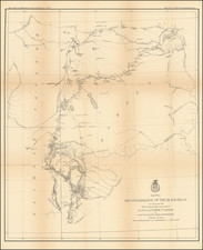
Scarce map of the various lands given to the Indian Tribes relocated in the 1830s, as mapped during the Dodge Expedition.
The map covers the region of present day Iowa, Nebraska, Kansas and Oklahoma. An inset provides tabulations of the numbers of Indians and a listing of estimated acres of land assigned to these Tribes. While it shows the Santa Fe Road, the route of Col. Dodge is not depicted.
The map is based on the 1835 map prepared by Lt. Washington Hood. Wheat calls it "an important historical map." This example is from the re-issue by the ASP Military Affairs.
Reference
Wheat, C.I. (TM) 418; Howes, W. K-161; Storm, C. 2335; Karrow, R.W. (Mid West) 1-1-83.


![[First Map of the Mississippi River] Carte de la decouverte faite l'an dans l'Amerique Septentrionale](https://storage.googleapis.com/raremaps/img/small/93571.jpg)
![[ Hungarian Traveler In the California and the West with a Comanche and Wichita to Hungarian vocabulary ] Levelei Éjszakamerikából -- Tizenkét eredeti rajzok után készült kő- és egynéhány fametszettel. Közli Prépost István (Letters from North America)](https://storage.googleapis.com/raremaps/img/small/98502.jpg)