This item has been sold, but you can enter your email address to be notified if another example becomes available.


|
||

|

|
|

|
Stock# 99736
Description
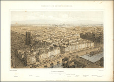
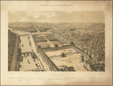
Striking plan of Paris, illustrating the city in the first part of the 19th Century.
The map provides a remarkable schematic overview of the city, identifying major public buildings, parks, monuments, bridges and other points of interest.
Several keys on the outer parts of the map lists names and coordinates of Paris streets.