|
||

|

|
|

|
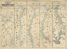
Terrific rare 2-sheet military map of the United States shortly after the conclusion of the American Civil War.
Shows roads, railroads, towns, lakes, rivers, islands, bays, harbors, forts, military reservations, Indian reservations, and many other details. While the various states and territories of the Trans-Mississippi West are now well settled, the map is rich with early ephemeral details. Dozens of Indian Tribes, Villages and Reservations are denoted. Yellowstone appears. Interesting mining details and mountain elevations are shown. The map is also a marvelous amalgam of Topographical information.
The style and detail of this map surpasses most American maps of the West and the detail is exceptional. Dozens of Military Forts and encampments are shown, many of which are not located on most contemporary maps. One of the best and scarcest commerical atlas maps of the period.
![The Theatre of War in North America, with the Roads, and Tables, of the Superficial Contents, Distances, &c.a By and American [with] A Compendious Account of the British Colonies in North-America.](https://storage.googleapis.com/raremaps/img/small/81762.jpg)
![[Shows Republic of Texas] United States and Texas](https://storage.googleapis.com/raremaps/img/small/101139.jpg)