|
||

|

|
|

|
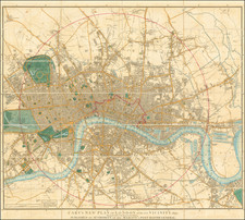
Outline and Adjacent Region of the Metropolis of London
Highly detailed decorative map of London and Environs, extending to Gravesend in the east, Hatfield and St. Albans in the North, Westerham in the South and Uxbridge in the West.
The title "Delineatio ac finitima Regio Magnae Brittaniae Metropoleos Londini ad novissimam Normam repraesentata et escusa" can be translated as "The Outline and Adjacent Region of the Metropolis of London in Great Britain, Represented and Printed According to the Latest Standards."
The map shows the various towns, roads, churches, fortified cities, rivers, harbors, etc. in and around London, including a town plan.
A nice post-fire map of the region, showing the extent of the expansion of London, which would grow to many times the size illustrated here.
Matthäus Seutter (1678-1757) was a prominent German mapmaker in the mid-eighteenth century. Initially apprenticed to a brewer, he trained as an engraver under Johann Baptist Homann in Nuremburg before setting up shop in his native Augsburg. In 1727 he was granted the title Imperial Geographer. His most famous work is Atlas Novus Sive Tabulae Geographicae, published in two volumes ca. 1730, although the majority of his maps are based on earlier work by other cartographers like the Homanns, Delisles, and de Fer.
Alternative spellings: Matthias Seutter, Mathaus Seutter, Matthaeus Seutter, Mattheus Seutter