|
||

|

|
|

|
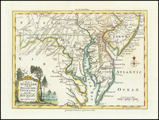
Stock# 103074
Description
Detailed map of Maryland and Delaware, showing counties, towns, roads, rivers, lakes, islands, creeks, etc.
Inset of the continuation of the Potowmac River from Fort Cumberland. One of the earliest maps of Maryland and Delaware printed in the United States.
Condition Description
Engraving on 18th-century laid paper. Uncolored map. Some minor foxing and toning. Trimmed slightly past plate mark on lefthand side.
Reference
Wheat & Brun 519.
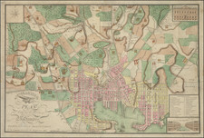
![[ Baltimore ] Map of the City and Suburbs of Baltimore Compiled from Actual Surveys 1853 . . .](https://storage.googleapis.com/raremaps/img/small/102136.jpg)