


|
||

|

|
|

|
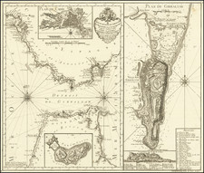
This 1639 map by cartographer Jean-Étienne Lasne is a depiction of the French military advance into the County of Roussillon, set against the backdrop of the Franco-Spanish War. It covers key locations in the Province of Roussillon, including Étang de Salses, Salses, Leucate, and Perpignan.
The map's eastern edge features the Mediterranean Sea, dotted with French naval vessels. Prominently displayed are the coat of arms of France and Navarre, as well as a detailed portrayal of the Fortress of Salses, illustrating the strategic importance of this area during the period.
The Fortress of Salses-le-Château, designed by Spanish architects as a bulwark against French incursions, stands out as a focal point of conflict. It changed hands several times between the French and Spanish forces, reflecting the ongoing territorial conflicts of the time.
The map details the 1639 siege of Salses-le-Château and its surrounding area, highlighting the short-lived nature of military victories in this era. It is a vivid cartographic record of the siege tactics and defenses.
Fortress Salses
The Forteresse de Salses, a fortress in the Pyrénées-Orientales region of France, was originally constructed by Spain as a defensive bulwark against French expansion. This historic fortification, initiated in 1495 under the directive of Queen Isabella I of Castile and King Ferdinand II of Aragon, was a response to the evolving military landscape influenced by the Italian Wars. The fortress, a brainchild of Francisco Ramiro Lopez, King Ferdinand II’s premier artilleryman, commenced construction in June 1497 and was completed at the substantial cost of 116,601 gold ducats in 1503.
Strategically situated on a narrow strip of land, Salses commanded views of the Mediterranean Sea and the Corbiere hills, lying on a historically volatile frontier between Spain and France. Its strategic value was recognized as early as Roman times when a small castrum named Salsulae was established in the vicinity.
The Fortress of Salses stands as a sentinel on a rocky promontory, first mentioned in the 11th century. Historically significant as the seat of the Counts of Roussillon, it was under the dominion of the Catalan-Aragonese rulers rather than the kingdom of France. Constructed to oversee and protect the critical border crossing between France and Spain, the fortress was a strategic initiative of the Catholic monarchs, Ferdinand II of Aragon and Isabella of Castile. This imposing structure served a dual purpose: a surveillance post and a defensive bulwark against northern adversaries. The delineation of the Franco-Spanish border at the time, marked by the Corbières mountains, underscored the fortress's significance in medieval geopolitics.
The fortress's history is marked by several sieges. In 1503, it withstood its first French siege, followed by a period of relative peace. However, in 1639, it was captured by the French, only to be retaken by the Spanish in 1640. The Treaty of the Pyrenees in 1659 eventually ceded this territory to the French crown, shifting the frontier southwards.
In the 17th century, the fortress's role evolved. Post the poisons affair of 1682, it was converted into a prison by royal decree, leading to the tragic fate of 19 convicts who were walled up alive. Military engineer Vauban deemed the fortress obsolete in the late 17th century, although it was spared demolition due to high costs. It served as a gunpowder magazine in the 19th century, undergoing minor refurbishments for safe storage.
Recognized as a historic monument in 1886, the fortress was decommissioned in 1889. It later came under the administration of the French Ministry of Culture, symbolizing a transition from a medieval bastion to a cultural heritage site, preserving its historical legacy for future generations.
Despite the fort’s impressive design and strategic significance, it eventually succumbed to French forces in the mid-17th century, marking a shift in regional power dynamics. The loss of Salses to France was symptomatic of Spain’s overextension and eventual decline as a European power, a narrative echoed in the fort's history. The Treaty of the Pyrenees in 1659 formalized this shift, transferring the control of territories, including the region encompassing Salses, from Spain to France.
![[Manuscript Map of Gibraltar]](https://storage.googleapis.com/raremaps/img/small/66061.jpg)
![[Cannes, Pointe Croisette, Ile Sainte Marguerite, Ile Saint-Honorat]](https://storage.googleapis.com/raremaps/img/small/70870.jpg)
![[ Provence ] Carte de Provence](https://storage.googleapis.com/raremaps/img/small/103397.jpg)