


|
||

|

|
|

|
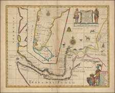
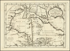
Rare Early Edition of John Narbrough's Map of Magellan's Strait
Rare English map of the Straits of Magellan and contiguous regions, based upon the reports of John Narborough, the first English mariner to sail through the Straits of Magellan.
First issued in 1673, this is the first English chart to detail the Straits of Magellan following Narborough's expedition. The map provides one of the most detailed treatments of the region and certainly the most detailed map of the region printed in England in the 17th Century.
Sir John Narborough was an English navigator, born in Norfolk in 1637. Narborough entered the navy as a midshipman, served during the war with the Dutch in 1664, and was given in 1669 the command of an expedition to the South sea. He explored the coast of Patagonia and crossed through the Straights of Magellan in the fall of 1670. He then sailed along the Chilian coast as far as Valdivia, but, being denied entrance to that harbor by the Spanish authorities, he returned to England.
In 1671, Narborough served under the Duke of York at the battle of Solebay. He was made rear-admiral and knighted in 1673, commanded the expeditions against Tripoli in 1674 and Algiers in 1677, and was appointed in 1680 commissioner of the admiralty, which post he held till his death in 1688. The narrative of his expedition to the South sea, written in collaboration with his lieutenant, Pecker, was published in the series "An Account of Several Late Voyages and Discoveries to the South and North" (London, 1694).
This is the fourth state of the map.
Rarity
The map is extremely rare.
John Thornton was a respected and prominent chartmaker in London in the latter part of the seventeenth century. He was one of the final members of the Thames School of chartmakers and served as the hydrographer to the Hudson's Bay Company and the East India Company. He produced a large variety of printed charts, maps, and atlases in his career, but he was also a renowned manuscript chart maker. Born in London in 1641, he was apprenticed in the Drapers Company to a chartmaker, John Burston. After being made free of the company (1665), he was part of the combine that took over John Seller’ English Pilot in 1677. Thornton was trusted by the naval and navigational establishment of the day; one of his clients was Samuel Pepys, naval administrator and diarist. Thornton died in 1708, leaving his stock to his son, Samuel, who carried on the business.
Samuel, born in ca. 1665, also had apprenticed in the Drapers Company and was made free a year after his father’s death. He continued the business until 1715, when he died. His stock then passed to Richard Mount and Thomas Page.
![[Parts for a Klinger globe]](https://storage.googleapis.com/raremaps/img/small/46375.jpg)