


|
||

|

|
|

|
Stock# 99717
Description
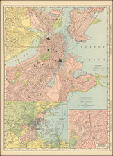
One of the earliest obtainable maps of Boston
Interesting and detailed map of the Port of Boston and Vicinity, published at the conclusion of the French & Indian War.
Includes towns, Islands, soundings, etc.
From the Gazzettiere Americano published in Livorno in 1763, based upon an earlier work by Thomas Jefferys, which did not include any maps.
![[Massachusetts Bay, with Boston and Part of Cape Cod]](https://storage.googleapis.com/raremaps/img/small/59282.jpg)