|
||

|

|
|

|
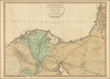
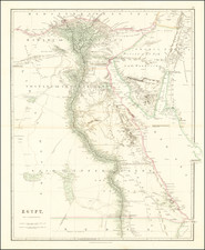
Egyptian Coast Guard Service Map Showing Cost of Coastal Defenses on the Eve of the Urabi Revolt
Detailed hand drawn map of a portion of the coast of Egypt from Sidi Abd el Rahman on the Mediterranean Sea to the city of Suez, which lies at the southern end of the Suez Canal where it meets the Red Sea.
The map was drawn by J. Schranz, under the direction of S.E. Morice Bey, who was then serving as the Inspector General of the Egyption Coast Guard, on January 10, 1879. The map was prepared at a time when Egypt's Government was in the midst of a financial crisis, with Britain and France closely monitoring financial expenditures of the government.
The primary purpose of the map would seem to be illustrating the cost of defending the Egyptian Coastline, based on an annual basis, with the coastline broken up into 8 numbered sections on the Mediterranean Coast and a ninth at the mouth of the Suez Canal where it enters the Red Sea. The profile view at the top provides a similar schematic look at the regions covered.
It would seem that the areas in blue are those well defended by the Egyptian Coast Guard, while the areas in red are less well defended, corresponding with the amounts set for
Drawn by J. Schranz, under the direction of S.E. Morice Bey, who was then likely serving as the Inspector General of the Egyption Coast Guard, the map gives a finely detailed accounting of the coastline
Dashed lines show the Caravan routes in the region. The map notes near Ismailla that "There is no Coast Guard Service in Ismailla, but there is a Customs Service."
Egypt and the Suez Canal
In the second half of the 19th Century, leadership of Egypt was in flux. Muhammad Ali was succeeded briefly by his son Ibrahim (in September 1848), then by a grandson Abbas I (in November 1848), then by Said (in 1854), and Isma'il (in 1863). Abbas I was cautious. Said and Ismail were ambitious developers, but they spent beyond their means.
The Suez Canal, built in partnership with the French, was completed in 1869. The cost of this and other projects had two effects: it led to enormous debt to European banks, and caused popular discontent because of the onerous taxation it required. In 1875, Ismail sold Egypt's 44% share in the canal to the British Government. Ismail also tried to conquer the Ethiopian Empire and was defeated twice at Gundet in 1875 and again at the Battle of Gura in 1876.
By 1879, the financial woes of Egypt led to the imposition of British and French controllers who sat in the Egyptian cabinet, and, "with the financial power of the bondholders behind them, were the real power in the Government."
Local dissatisfaction with Ismail and with European intrusion led to the formation of the first nationalist groupings in 1879, with Ahmad Urabi a prominent figure The ʻUrabi revolt" was a nationalist uprising in Egypt from 1879 to 1882. It was led by and named for Colonel Ahmed ʻUrabi or Orabi, and sought to depose the Khedive Tewfik Pasha and end British and French influence over the country. The uprising was ended by the Anglo-Egyptian War and the British takeover of the country. Britain and France intervened militarily, bombarding Alexandria and crushing the Egyptian army at the battle of Tel el-Kebir. They reinstalled Ismail's son Tewfik as the figurehead of a de facto British protectorate.
![[Alexandria] Alexandrie](https://storage.googleapis.com/raremaps/img/small/81819.jpg)