|
||

|

|
|

|
John Ogilby's English Edition of the Jansson Visscher Map
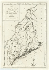
This exquisite full hand-colored map, created by John Ogilby, represents the Northeast of North America, spanning from the St. Lawrence River and New England to the Chesapeake Bay, with a focal point on Long Island, accurately depicted as an island.
The map features an intricate illustration of Europeans and Native Americans engaged in trade, reflecting the interactions and exchanges that characterized the colonial era. The detailed cartography along the Atlantic Coast, Hudson River, Delaware River and Bay, and the Chesapeake highlights the comprehensive geographic knowledge of the period. Notable embellishments include a compass rose and various animals within the map's body, elements retained from the earlier editions by Jansson and Visscher.
The Jansson-Visscher Map
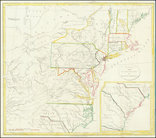
Ogilby’s map is drawn from the so-called Jansson-Visscher map of 1651, the first in a series of maps that profoundly re-shaped the cartographic representation of the northeastern United States for the rest of the 17th century. The Jansson-Visscher map is the earliest collectible map to present the correct shapes of Manhattan and Long Island and to depict Swedish settlements in New Jersey along the Delaware River. It meticulously records every known settlement in the Northeast at the time, including the early English colonies along the Connecticut coast, as well as the indigenous tribes encountered by Europeans.
This map's significance extends to its synthesis of mid-17th century geographic knowledge. According to historical sources like Stokes, its overall outline is derived from a now-lost map by Peter Minuit around 1630, which itself integrated earlier maps by John Smith, Adriaen Block, and others. The map portrays a coherent depiction of the coastal region and major river systems, reflecting the vital role these features played in early colonial settlement patterns.
Additionally, the map incorporates recent information from surveys conducted during the early years of New Netherland, suggesting it shares sources with the Van der Donck manuscript map. Some speculate that this map is a reduced version of a manuscript map by Augustine Herman or Van der Donck, further underscoring its historical importance. Early place names and Indian villages, such as Breukelen, Springfield, Windsor, Hartford, and New Haven, are prominently featured, illustrating the nascent stages of English settlement in the region.
The Jansson-Visscher map, in its various iterations, remained the most influential map of the northeastern United States for nearly 40 years, celebrated for its detailed cartouches, depictions of forts, and illustrations of animals, all of which contribute to its historical and aesthetic value.
John Ogilby (1600-1676) was an English geographer and publisher, one of the most prominent of the seventeenth century. Little is known of his early life but by 1619 he was apprenticed to John Draper, a dancing-master in London. He worked as a dancing-master, courtier, and theater owner form 1620-1641. From 1649 he worked as a poet, translator, and publisher of classical texts. It is only in the last decade of his life that he entered into geography.
In 1649, Ogilby published his first translation, of Virgil, and continued to put out translations in the 1650s and 1660s. In March 1661 he was reconfirmed as master of revels in Ireland and appointed master of the king’s imprimeries, or king’s printer. From 1662 to 1665 he was in Ireland, where he most likely met Robert Boyle. He returned to London only to lose much of his printing stock in the Great Fire of 1666. Post-fire, he became assistant surveyor to the city, where he met Robert Hooke and Christopher Wren.
In 1669, Ogilby published Embassy to China. At the same time, he planned to release atlases that would cover the entire world. These atlases would be funded via subscriptions, advertisements, and lotteries—all common practice at the time, especially for expensive multi-volume works. He released Africa and Atlas Japannensis in 1670, America in 1671 and Atlas Chinensis in 1671, and Asia in 1673. Ogilby compiled the works based on materials produced by others and they reflect a growing interest in the wider world within England.
In 1671, while producing the atlases, Ogilby secured another royal title, that of his Majesty’s cosmographer. He used this title when publishing Britannia in 1675, his best-known work. The Britannia is best described as a road atlas; it shows 2519 miles of road in 100 strip maps. This technique would be widely adopted in the subsequent century. His method of measuring with a waywiser, a large wheel, also helped to standardize the distance of the English mile at 1760 yards. The Britannia was a major achievement in early English cartography and was republished in 1698, 1719, and 1720.
![[Niagara Falls] Cataracte de Niagara](https://storage.googleapis.com/raremaps/img/small/96890.jpg)