|
||

|

|
|

|
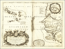
Finely embellished Dutch Sea chart of the coast from Sierra Leone to Cote d'Ivore, decorated with Elephants and indigeous peoples, including Ivory hunters.
Published by the leading family of Dutch sea chartmakers of the perod, the chart is perhaps the most detailed representation 17th Century charting of this part of the West African coast, stretching from Sierra Leone to the Ivory Coast (Côte d'Ivoire), a region of significant strategic importance in the burgeoning trade networks of that era.
Meticulously charting from Sierra Leone in the northwest, known for its rich natural harbors and as a trading nucleus for commodities like gold and ivory, the map extends to the southeast, capturing the expanse of the Ivory Coast. This region, synonymous with its namesake trade in ivory, was a critical component of the Dutch's expanding trading network in West Africa. The detailed coastal outlines and annotations in the chart are a testament to the Dutch’s mastery in blending navigational precision with commercial acumen.
In the 17th century, Dutch maritime interests were heavily focused on these parts of West Africa. The era saw the Dutch, initially lured by the lucrative trade in gold and ivory, establish a network of trading posts and forts along the coast. Notable among these was Fort Nassau, built in 1612 in what is now Ghana, serving as a critical outpost for Dutch operations in the region. This period also marked the expansion of Dutch trading activities, extending beyond gold and ivory to encompass other commodities, reflecting the rich trade dynamics of West Africa. With the growing success of commerce in the region, the Dutch faced rivalry from other European powers, especially the Portuguese, British, and French. These conflicts often led to shifting controls over strategic trading posts and territories along the coast. The Dutch West India Company, established in 1621, played a pivotal role in orchestrating these trade ventures. Under its auspices, Dutch influence in the region grew, marked by both economic gains and the complex interplays of European expansionism.
The Van Keulens were a family of chartmakers and publishers. The firm, In de Gekroonde Lootsman (In the Crowned Pilot), was founded in 1678 by Johannes van Keulen (1654-1715). Van Keulen originally registered his business as a vendor of books and instruments (specifically cross-staffs). In 1680, however, he gained a privilege from the States of Holland and West Friesland for the publication of pilot guides and sea atlases.
In that year, van Keulen released his Zee-Atlas (Sea Atlas), which secured him a name in the competitive maritime publishing market. In 1681, he published the first volume of Nieuwe Lichtende Zee-Fakkel (New Shining Sea Torch). This would be the first of an eventual five volumes originally published between 1680 and 1684. A sixth volume was added in 1753. The Zee-Fakel won van Keulen lasting fame. The atlas had charts compiled by Claes Jansz Vooght and artwork from Jan Luyken. It proved immensely popular and was reprinted until 1783. There were translations in French, English, Spanish, and Italian.
The late-seventeenth century was an auspicious time to enter the maritime chart business. Previous industry leaders had either closed shop, died, or retired, leaving space for a new competitor. Van Keulen proceeded to buy up the stock and privileges of several maritime publishing firms; the most notable was the stock of Hendrik Doncker, acquired in 1693.
Johannes’ son, Gerard (1678-1726) took over the business upon his father’s death. Gerard was a skilled engraver and mathematician. His talents were noticed, as in 1706 he was named as Hydrographer to the Dutch East India Company (VOC).
In turn, Gerard’s son Johannes II (1704-1770) came to run the shop. He was also tied to the VOC, and his role as their chartmaker allowed his charts to be considered as quasi-official government documents. It is with access to formerly clandestine VOC geographic knowledge that Johannes the Younger was able to add a sixth volume to the Zee-Fakkel, which covered the East Indies. Johannes also continued to sell instruments, including the recently-invented Hadley’s Quadrant from 1744.
When Johannes II died in 1770, his widow ran the business in his stead, aided by her two sons, Cornelis Buys (1736-1778) and Gerard Hulst (1733-1801). Now a century old, the family business had extended to include an anchor factory. After Cornelis died in 1778, Gerard took on the management of the firm alone. He oversaw the introduction of sextants to their inventory and published the Dutch Nautical Almanac beginning in 1788. Annual editions appeared until 1885. Gerard also served as an original member of the Dutch Commission for Longitude at Sea from 1787.
Gerard’s widow ran the business for nine years after his death, when their son, Johannes Hulst, started to lead the firm in 1810. After his death in 1844, the firm passed out of family hands and into the control of Jacob Swert, a skilled cartographer who had worked for the business for two decades. He passed the work to his son, another Jacob, in 1866. By the mid-nineteenth century, the conversion from sail to steam had diminished the size of the market for charts. Fewer sailors needed fewer maps, charts, and instruments. In 1885, after 207 years in business, In de Gekroonde Lootsman closed its doors and auctioned its stock.
![[Republic of Liberia]](https://storage.googleapis.com/raremaps/img/small/76840.jpg)
![The Prospect of the Island of Goeree & the Fort Vermandoise alias St. Michael (with) A Plan of the Island Goeree in Nigritiae (and) [Plan of Fortifications]](https://storage.googleapis.com/raremaps/img/small/92044.jpg)
![[West Coast Africa: Sierra Leone, Liberia and Guinea]](https://storage.googleapis.com/raremaps/img/small/40123.jpg)