


|
||

|

|
|

|
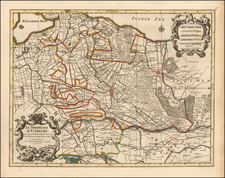
Fine old color example of Henricus Hondius' map of the Duchy of Gelderland, first published in 1629.
Henricus Hondius’ map shows the Duchy of Gelderland, extending to include parts of Utrecht and Brabant, a region of significant historical interest in the Netherlands. Created in the 17th century, this work is not only a cartographic achievement but also a piece of art, indicative of the high level of craftsmanship of the period.
The map provides a detailed portrayal of Gelderland, illustrating numerous cities of import such as Nijmegen, Eindhoven, Zutphen, and Zwolle, along with the intricate network of roads, rivers, and forests that define the region.
Oriented with west at the top, the map includes a grand title cartouche and a secondary cartouche, with the makers name, the date and mileage scales. The inclusion of sailing ships in the Zuyder Zee adds a dynamic element, suggesting the vibrancy of trade and travel in the region.
The map’s lineage is attributed to the work of Balthasar Floris van Berckenrode.
Henricus Hondius (1597-1651) was a Dutch engraver and mapmaker, a member of a prominent cartographic family. His father, Jodocus Hondius, was also an engraver and geographer. While working with his father, Henricus was instrumental in the expansion and republishing of Mercator’s atlas, first published in 1595 and republished by Hondius in 1606.
Upon his father’s death in 1612, Henricus and his brother, Jodocus the Younger, took over the business. He set up his own shop in 1621, where he continued to release new editions of the Mercator atlas. Later, he partnered with his brother-in-law, Jan Janssonius, in continuing to expand and publish Mercator’s atlas, which would become known as the Mercator-Hondius-Janssonius atlas. Born and based in Amsterdam, he died there in 1651.
![[ Holy Roman Empire ] Nova Totius Germaniae Descriptio Geographica](https://storage.googleapis.com/raremaps/img/small/95672.jpg)
![[Denmark, Netherlands, Belgium, North Sea] Europ IIII Tab](https://storage.googleapis.com/raremaps/img/small/89170.jpg)