|
||

|

|
|

|
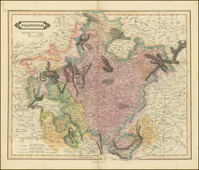
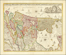
Stunning full original color example of Blaeu's two part map of the course of the Rhine, Waal & Meuse Rivers, first published in 1630.
"Detailed map of a stretch of Western Europe's most influential rivers: the Rhine, Meuse, and Waal, from Rheinberg to Gorinchem, including adjacent territories of the Duchy of Cleves, the Kingdom of Nijmegen, and the Bommelerwaard. This map by Willem Janszoon Blaeu encapsulates the intertwined waterways and regional power in the 17th century.
The map's significance emanates from its detailed representation of a region that was central to the economic and military strategies of European powers. The Rhine and Meuse rivers were crucial trade arteries that facilitated the flow of goods and culture between the hinterlands of Europe and its coastal ports. The inclusion of the Waal reflects its importance as a distributary of the Rhine, cementing the region's role as a conduit for commerce and sustenance. The cartographic precision exemplified in this map was paramount for navigators and merchants during an era when river trade was a cornerstone of economic prosperity.
The territories marked—Duchy of Cleves, the Kingdom of Nijmegen, and the Bommelerwaard—are depicted with a high degree of accuracy and detail, reflective of their strategic import and contested sovereignties. The Duchy of Cleves was particularly significant during the period, often caught in the ambitions of larger powers due to its position and resources. The Kingdom of Nijmegen, with its rich history dating back to the Roman era, was a focal point of cultural and political influence. Meanwhile, Bommelerwaard, a river island in the province of Gelderland, represented the intricate relationships between land management, water control, and regional jurisdiction, which were central preoccupations in the Dutch Republic.
Willem Janszoon Blaeu (1571-1638) was a prominent Dutch geographer and publisher. Born the son of a herring merchant, Blaeu chose not fish but mathematics and astronomy for his focus. He studied with the famous Danish astronomer Tycho Brahe, with whom he honed his instrument and globe making skills. Blaeu set up shop in Amsterdam, where he sold instruments and globes, published maps, and edited the works of intellectuals like Descartes and Hugo Grotius. In 1635, he released his atlas, Theatrum Orbis Terrarum, sive, Atlas novus.
Willem died in 1638. He had two sons, Cornelis (1610-1648) and Joan (1596-1673). Joan trained as a lawyer, but joined his father’s business rather than practice. After his father’s death, the brothers took over their father’s shop and Joan took on his work as hydrographer to the Dutch East India Company. Later in life, Joan would modify and greatly expand his father’s Atlas novus, eventually releasing his masterpiece, the Atlas maior, between 1662 and 1672.
![[ Bad Pyrmont ] Prospectus Principalis Waldec censis et Novae Urbis Pyrmontii, cum cicinis et adacentibus Fontibus Mineralibus et finitimis locis aeri incisus et excusus . . . .](https://storage.googleapis.com/raremaps/img/small/97093.jpg)