|
||

|

|
|

|
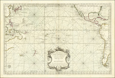
A detailed map of the Pacific, published by J. Goujon in Paris in 1822, epitomizing the 19th-century cartographic endeavors to delineate the Pacific region and encompassing the vast and diverse territories often referred to as Oceania. This early 19th-century map is particularly notable for its detailed representation of the Australian continent, then known as New Holland, alongside the myriad of Pacific islands scattered across the ocean's expanse.
The year 1822 marked a period of heightened European interest in the Pacific, fueled by exploration, colonial ambitions, and the scientific urge to chart the unknown. The map stands as a testament to the French contributions to these global explorative efforts, which were not only driven by the pursuit of territorial claims but also by a quest for knowledge and the advancement of science.
With precision that reflects the cartographic techniques of the era, the map details coastlines, ocean currents, and nautical routes that were critical for voyages at the time. The intricate depiction of the archipelagos and the tentative outlines of lesser-known landmasses indicate the evolving understanding of Pacific geography.
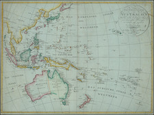
Andre Hubert Brué was a French geographer and cartographer. Born in Paris, he served in the French Navy, joining the Baudin expedition to the Pacific (1800-1804). After his sea service, Brué applied his navigation and charting skills to creating finely-crafted maps, which were renowned for their crisp engraving and accuracy. He drew directly on the copper of the plate, creating what he called encyprotypes. He is best known for the Atlas universal de géographie physique, politique, ancienne et moderne.