|
||

|

|
|

|
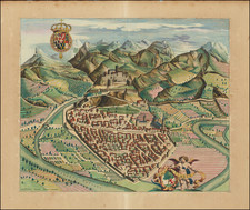
Detailed maps of the territories of Styria and Carniola, each within an ornamental Renaissance cartouche that serves both as a frame and an embellishment.
The maps, influenced by the earlier works of Wolfgang Lazius, incorporate a dual representation of these territories with neighboring regions in a manner that is both scholarly and artistic.
The map of Styria is characterized by the dominant courses of the Drava and Mura rivers, tracing their paths to the Confluentes Muerae et Draus. It extends from the Seeberg in the west, Celje along the Savinja River, to Varaždin in the east, capturing the essence of the landscape with a schematic yet discerning eye. The inclusion of small stylized views of towns and villages, such as Graz with its notable bridges on the Mura and Maribor at the Drava crossing, adds a layer of cultural and geographic specificity. The term NORICI MEDITERRANEI, marked north of Graz, alludes to the ancient Noricum region, hinting at a historical depth that surpasses the map's immediate utility.
The map of the Duchy of Carinthia is equally rich in detail, featuring the Drava River and its tributaries as a central motif, flowing from St. Peter in Holz to Dravograd. It encompasses significant urban centers such as Villach and Klagenfurt and stretches south to the Trieste Bay and Aquileia. This chorographic representation, typical of the Austrian humanists' preferences, demonstrates a round shape that, while popular, sometimes distorts the recognition of marginal lands and geographical features.
These maps, while schematic, capture the essential hydrographic and orographic elements of their regions. The round plates, devoid of scale, focus on the essence rather than the exactitude of the landscape. The marginal lands, depicted with less detail and more stylization, reveal the limitations of scale and the author's selective emphasis. Yet, it is precisely this stylization that speaks to the era's cartographic trends, characterized by a blend of functional representation and artistic abstraction.
Gerard De Jode (1509-1591) was a pre-eminent mapmaker in the late seventeenth century, a time when the Dutch dominated the map trade. He was known for his many maps, some of which featured in Speculum Orbis Terrae (first edition Antwerp: 1578). Although never as successful as Ortelius’ Theatrum, the Speculum did get republished in a second edition in 1593, two years after De Jode’s death, by Arnold Coninx, and included this map. After his death, Gerard’s son, Cornelis (1568-1600), and his wife, Paschina, ran the shop. Unfortunately, Cornelis died young in 1600, aged only 32, and the stock and plates were sold to the publisher Joan Baptista Vrients.
![Hungaria Ungarn [Hungary, Slovakia, Northern Croatia and Northern Serbia]](https://storage.googleapis.com/raremaps/img/small/76437mp2.jpg)
![[ Holy Roman Empire, Poland, Baltic, etc. ] Germania VI Nova Tabula (First state!)](https://storage.googleapis.com/raremaps/img/small/94645.jpg)
![[ Bad Gastein ] Wildbad Gastein](https://storage.googleapis.com/raremaps/img/small/96453.jpg)