|
||

|

|
|

|
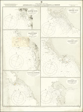
Fine Admiralty chart illustrating the topography and hydrography of the southern tip of the Baja California peninsula, from Cape San Lucas to Espiritu Santo and Sta. Margarita Islands. Published in London under the auspices of the Admiralty in the early 20th century -- this example has been updated numerous times to 1933 -- the map bears testament to the exhaustive surveying efforts of the era.
Engraved with utmost precision, the map's design lays bare the coastline's multifaceted nature, detailing its various inlets, bays, and islands with soundings delineated in fathoms. Tidal variations for specific locations, such as Sta. Margarita Island and San José del Cabo, are enumerated, providing invaluable information for sailors of the time..
Topographical features like mountains, valleys, and arroyos are carefully delineated, offering viewers a comprehensive overview of the region's terrestrial layout. Furthermore, legends and annotations abound, including a detailed key for understanding the various symbols and markings employed throughout the chart.
The map's upper corner proudly displays the Admiralty's seal, signifying its official status. Below this emblematic detail, one can find the pricing information, marked at "Price Three Shillings."
Publication was overseen by Rear Admiral Sir W.J.L. Wharton, K.C.B, F.R.S., serving as the Hydrographer at the time.
The British Admiralty has produced nautical charts since 1795 under the auspices of the United Kingdom Hydrographic Office (HO). Its main task was to provide the Royal Navy with navigational products and service, but since 1821 it has also sold charts to the public.
In 1795, King George III appointed Alexander Dalrymple, a pedantic geographer, to consolidate, catalogue, and improve the Royal Navy’s charts. He produced the first chart as the Hydrographer to the Admiralty in 1802. Dalrymple, known for his sticky personality, served until his death in 1808, when he was succeeded by Captain Thomas Hurd. The HO has been run by naval officers ever since.
Hurd professionalized the office and increased its efficiency. He was succeeded by the Arctic explorer Captain William Parry in 1823. By 1825, the HO was offering over seven hundred charts and views for sale. Under Parry, the HO also began to participate in exploratory expeditions. The first was a joint French-Spanish-British trip to the South Atlantic, a voyage organized in part by the Royal Society of London.
In 1829, Rear-Admiral Sir Francis Beaufort was appointed Hydrographer Royal. Under his management, the HO introduced the wind force scale named for him, as well as began issuing official tide tables (1833). It was under Beaufort that HMS Beagle completed several surveying missions, including its most famous voyage commanded by Captain FitzRoy with Charles Darwin onboard. When Beaufort retired in 1855, the HO had nearly two thousand charts in its catalog.
Later in the nineteenth century, the HO supported the Challenger expedition, which is credited with helping to found the discipline of oceanography. The HO participated in the International Meridian Conference which decided on the Greenwich Meridian as the Prime Meridian. Regulation and standardization of oceanic and navigational measures continued into the twentieth century, with the HO participating at the first International Hydrographic Organization meeting in 1921.
During World War II, the HO chart making facility moved to Taunton, the first purpose-built building it ever inhabited. In 1953, the first purpose-built survey ship went to sea, the HMS Vidal. Today, there is an entire class of survey vessels that make up the Royal Navy’s Hydrographic Squadron. The HO began to computerize their charts in the late 1960s and early 1970s. In 1968, the compilation staff also came to Taunton, and the HO continues to work from there today.
![[Baja California--Cabo San Lucas] Amer. Sep. No. 58 Partie De La Vielle Californie [and] Amer. Sep. No. 63 Partie De La Vielle Californie](https://storage.googleapis.com/raremaps/img/small/100744.jpg)