|
||

|

|
|

|
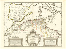
The First Major Geological Mapping of Northern Africa
Two finely executed geological maps representing the north and south of parts of the Province of Algeria with color-coded mineralogical and geological legends.
The map shows 106 mineralogical sites, each of which is cataloged and included in a table. The map was created by Ludovic Ville, an engineer at the Imperial Corps of Mines, to accompany his two volume work on the geology of Algeria, entitled Recherches sur les roches, les eaux et les gîtes minéraux des provinces d'Oran et d'Alger, par M. Ville et Notice minéralogique sur les provinces d'Oran et d'Alger par M.Ville, published in 1852 and 1858.
Ludovic-Gabriel-Alexandre-Raymond-Joseph Ville (1820-1877) stands as a seminal figure in the realm of geological and mineralogical research in 19th-century Algeria. Born on February 26, 1820, in Rivesaltes, France, Ville was an alumnus of the esteemed École Polytechnique (Class of 1837) and the École des mines de Paris. His extensive career in Algeria culminated in his role as an active service Inspector General, a position created uniquely in his honor in 1875, following three decades of devoted service.
The latter half of the 19th century in Algeria was a period of intense scientific inquiry and exploration, particularly in the natural sciences. During France's colonial governance of Algeria, the discovery and mapping of mineralogical resources held both economic and geopolitical significance. Ville emerged as a key figure in this endeavor, ceaselessly traversing the terrains of Algeria to study its geological make-up. His work greatly aided the understanding of Algeria’s potential, not only in terms of its mineral wealth but also its hydrogeological resources.
Ville's scholarly contributions are both copious and impactful. Among his major works are volumes on the study of rocks, treatises on the mineral deposits in the provinces of Oran and Algiers, and specialized studies on the regions of Hodna and M'zab. A significant part of his research focused on the discovery of water resources, particularly those that could be harnessed through drilling. He was the first to publish a geological outline of the provinces of Oran and Algiers, scaled at 1/400,000, a groundbreaking achievement that substantiated the mineralogical cartography of the region. These works were published continuously, a testament to his enduring dedication to the scientific examination of Algeria's natural landscape.
In recognition of his extensive work and in tribute to his devotion to Algeria, a village near Algiers, Villebourg in Cherchell, was named after him in 1881. Ville passed away on May 10, 1877, in Algeria, leaving behind a legacy not only as a prolific researcher but also as a man deeply committed to his life’s work. His publications were acknowledged in the Livre du Centenaire (École Polytechnique), 1897, by Gauthier-Villars et fils, further solidifying his contributions to scientific understanding. Through his comprehensive studies and dedicated service, Ludovic-Gabriel-Alexandre-Raymond-Joseph Ville shaped the course of geological and mineralogical research in Algeria, indelibly inscribing his name in the annals of 19th-century scientific exploration.
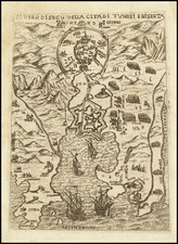
![Il Gerbi [Borj El Kebir, Tunisia]](https://storage.googleapis.com/raremaps/img/small/73716.jpg)