|
||

|

|
|

|
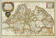
Mapping The Mount Everest Region and the Mountains of Nepal
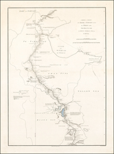
Highly detailed map of the Rolwaling Himal region in Nepal. The area is the western part of the Himalayan mountain range and is known for similar mountainous beauty to Everest. The other locations noted on the map are key points for planning summiting expeditions and are also renowned for their natural splendor.
The northern part of the map includes 22,000 foot mountains on either side of the Valley, notably the sacred peaks of Gaurisankar (Jomo Tseringma). Buddhist and Hindu belief teaches that these mountains are sacred spaces which meant that climbing and cartographic expeditions were not allowed until the early 1970s. In fact, the first ascent up Gaurisankar was only completed in 1979, the same year this map was published, by an American-Nepali team led by John Roskelley and Ang Dorje Sherpa.
Erwin Schneider & Mapping The Everest & Nepal
Erwin Schneider was both a prominent mountain climber and a cartographer. Starting in the 1930s, Schneider embarked on various expeditions in the Himalayas. His journeys covered a range of peaks, some of which were relatively unexplored at the time.
Schneider's contributions to cartography are notable, especially regarding the Himalayan region. He was instrumental in creating the first detailed topographical maps of the Everest region, employing the method of photogrammetry. This technique uses photographs for measurement and mapping, particularly useful for the rugged terrains of Nepal.
The work this series of maps dates back to 1959 with the inception of the Research Scheme Nepal Himalaya. The foundation of this scheme was under the leadership of Walter Hellmich, a distinguished zoologist. The first project was was the comprehensive mapping of the Mt. Everest region executed by Erwin Schneider. By 1977, Schneider's efforts culminated in the publishing of eight pivotal maps. These included detailed representations of East Nepal and the culturally significant Kathmandu Valley.
In 1961, the Fritz Thyssen Foundation assumed the responsibility of sponsoring various field research projects and bolstered the publication of the Khumbu Himal series of maps. Between 1960 and 1966, nine dedicated research groups, comprising 38 participants, embarked on diversified projects predominantly centered in East Nepal, notably the Dudh Kosi area. The resultant findings from these explorations found their way into prominent publications such as the Khumbu Himal and Hochgebirgsforschung series.
In 1965, the Research Council of the Research Scheme Nepal Himalaya became the Association of Comparative High Alpine Research. Nepal, with its diverse topography and rich culture, continued to be the focal point of this Association's endeavors. An interesting shift in the composition of the Association members was noted over the years. While initially dominated by natural scientists, representation from the humanities started to gain prominence, especially with the inclusion of ethnologists and human geographers.
Integral to their research processes was the establishment of a base in Kathmandu named the "Nepal Research Center", also colloquially known as the "Thyssen House". This center, aided by a bilateral treaty between Nepal and the Federal Republic of Germany, facilitated smoother customs procedures and granted crucial research permits. This center underwent a transition in 1974, with the German Oriental Society taking over the project and subsequently inaugurating a new Research Center in Ganabahal.