|
||

|

|
|

|
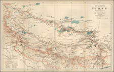
Fascinating map of the regions which are now part Odisha and Chhattisgarh created to illustrate Sir Richard Temple's paper to the Royal Geographical Society in 1865.
ir Richard Temple, 1st Baronet, was a British colonial administrator who left an indelible mark on 19th-century India. Born on March 8, 1826, he was known for his noteworthy administrative services in British India, rising to Governor of Bombay from 1877 to 1880. He was not just an administrator but also a scholar with profound interest in the geography, economy, and socio-cultural dynamics of the Indian subcontinent. One of his remarkable contributions is the 'Sketch Map of the Basin of Mahanuddy', which illustrated his article "On the Basin of the River Mahanuddy" in the Journal of the Royal Geographical Society of London, Volume 35.
The sketch map provides a comprehensive geographical depiction of the Mahanadi River watershed, focusing on the regions of Orissa (now known as Odisha) and Chhattisgarh. The Mahanadi River, one of India's major watercourses, discharges into the Bay of Bengal, creating a vital watershed region that underpins both agricultural and industrial growth.
Temple's map reflects the sweeping changes that the region underwent in the mid-19th century, primarily due to British expansionism. It illustrates the railways, lines of traffic, and traces the direction of a proposed tramway and the course of a proposed canal. These details are emblematic of the British Empire's efforts to strengthen trade, communication, and transport facilities in the region, thereby catalyzing economic development.
Significant cities in the region, namely Cuttack, Raipur, Nagpur, Gwalior (Gurrah), Jabalpur (Jubbulpoor), and Chandrapur (Chanda) are highlighted in the map. Cuttack, located on the Mahanadi River delta, was a crucial trading center and the capital of the British-administered Orissa Division of the Bengal Presidency. Raipur, nestled between the Maikal Hills and the Deccan Plateau, was a major administrative and economic hub in the Central Provinces.
Nagpur, then the capital of the Central Provinces and Berar, was another significant city due to its strategic location at the heartland of India and its prominence in trade. Gwalior (Gurrah), an important historical and administrative center, was known for its fort and its position along the main trade routes of Central India. Jabalpur (Jubbulpoor), known for its marble rocks and military cantonment, was a city of significance for trade and military operations. Chandrapur (Chanda), located in the south-eastern part of the Central Provinces, was a notable center of coal mining and power generation.
In essence, Sir Richard Temple's 'Sketch Map of the Basin of Mahanuddy' (1865) presents an insightful snapshot of the Mahanadi River Watershed and the regions of Orissa and Chhattisgarh during a period of significant transformation in mid-19th-century India. By highlighting the crucial cities and infrastructural developments of that era, the map offers historical narratives that underline the region's developmental journey. This contribution, along with Temple's other works, attests to his scholarly approach and adept administrative skills during his tenure in the British Empire.
![Colonel Mordaunt's Cock Match at Lucknow [Key Image]](https://storage.googleapis.com/raremaps/img/small/86563.jpg)