|
||

|

|
|

|
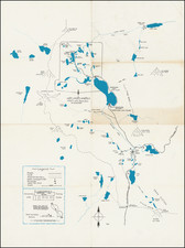
Manuscript Maps of 19th-century Stockton
Heavily Annotated for Railway Work
A set of three detailed 19th-century railroad map sheets showing most of downtown Stockton. The maps vividly illustrate the relationship of railroads to urban development in the burgeoning western transportation hub of Stockton. The three sheets, which are of varying dimensions, show the numbered city blocks of central Stockton, as well as numerous business establishments, all the major streets and several squares, including Washington Square and Lafayette Square. Mormon Channel, now called Mormon Slough, is a prominent feature on all three sheets. Though not specifically mentioned on the maps, the south bank of Mormon Slough was the site of an early Chinese community in Stockton.
Extensive pencil annotations suggests these maps were used by railroad engineers for construction or planning purposes. For instance, exact angles of railroad line curves are given, and there are notes on railroad towers, and the like. Other annotations relate to platforms or other construction along the railroad routes, included among these latter notes are outline sketches of buildings.
Mormon Slough the Stockton's Chinese Community
The name Mormon Slough serves as a reminder of the early contributions of the Mormon pioneers to the growth and development of Stockton and the broader San Joaquin Valley. It is likely named for early Mormon pioneers who settled in the region. However, the area around this waterway has a historical connection to the early Chinese community in Stockton. During the Gold Rush many Chinese traveled through Stockton on their way to the southern gold mines. While Stockton’s first Chinese settlers lived along Channel Street and Bridge Place, between North El Dorado and North Hunter Streets, a second Chinese community was established by the 1860s in the area around the south bank of the waterway, near a no-longer-extant corner of West Church and South Monroe streets. Chinese farmers irrigated vegetable crops in the area with water pumped from the slough. Over time, as Stockton grew and developed, parts of the slough were modified, filled in, or diverted to make way for urban development.
Dating the map
The map shows the route of the Stockton Electric Railway, which began operations in 1891. Based on this fact and the style and appearance of the maps, we estimate the maps to be from circa 1895.
Overview
At the time of the map Stockton was a nexus of trade and transport in California. With the state's rapid growth during and after the Gold Rush era, infrastructural developments like railways expanded greatly. Stockton, with its proximity to both the coast and the interior agricultural areas, evolved as an essential hub for both rail and water-based transportation. The development of waterway transportation is represented herein by Mormon Channel (or Mormon Slough), which branches southeast off of what is now Stockton Channel, an important regional waterway connected to the San Joaquin River. The presence of numerous milling companies and grain warehouses, as denoted on the map, underscored the city's role in the state's expanding agrarian economy.
Beyond its detailed urban representation, the map also serves as an artifact of engineering practices of the era. The extensive pencil annotations, detailing exact angles of railroad curves and the positioning of towers, are testimony to its utilization as a practical tool in the field. These notes, coupled with sketches of buildings and platforms, present a window into the meticulous planning and construction challenges faced by railroad engineers. Their scribbles and calculations provide insights into the on-ground realities of laying down tracks and establishing infrastructure in a rapidly urbanizing environment.
Several landmarks, including Union Square, Washington Square, Lafayette Square, and Columbus Square, are clearly marked, reflecting the city's efforts at urban planning and public space allocation amidst commercial pursuits. The pencil note mentioning the "Corral Hollow Franchise for Switch Track" hints at possible developments around track expansion.
These three manuscript maps of late 19th-century Stockton stand as visual representations of the interplay between urban growth, commercial interests, and infrastructural demands during a transformative period in California's history.
Places and sites noted on the maps:
- Mormon Channel
- Stockton Electric Railway route.
- A. & S. J. Ry. route.
- Union Square
- Washington Square (now under the Cross-town Freeway)
- Lafayette Square
- Columbus Square
- Catholic Cemetery
- Farmers' Co-Operative Union & Milling Co. Grain Warehouse
- California Navigation Co. Grain Warehouse
- Farmers' Co-Operative Union & Milling Co. Grain Warehouse.
- Crown Mills, Warehouse and Flour Mills.
- Lane's Warehouse, Balfour, Guthrie & Co.
- Simpson & Gray Lumber Yard.
- Sperry & Co. Grain Warehouse.
- Golden Gate & Union Flour Mills.
- Sperry Flour Mills
- California Steam Navigation Co. Freight Shed.
Example of the pencil notations:
Corral Hollow Franchise for Switch Track. From W. Line Edison St. to Within 500' W of Same to connect with C.P.R.R. , S.P.R.R. & S.F & S.J.V. R. R.
Rarity
Such unique 19th-century manuscript maps of California cities are rare in the market.
![California Wine Land of America [Sauterne, Burgundy]](https://storage.googleapis.com/raremaps/img/small/93654.jpg)
![[First Obtainable Map to Name California] Tartariae Sive Magni Chami Regni typus](https://storage.googleapis.com/raremaps/img/small/82510.jpg)
![[ Republic of Texas ] Central America II. Including Texas, California and the Northern States of Mexico](https://storage.googleapis.com/raremaps/img/small/93534.jpg)