|
||

|

|
|

|
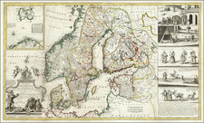
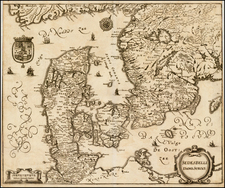
Jan Jansson's mid-17th century map of Gothia, southern Sweden, is an excellent example of cartographic work from that period.
Gothia, or Götaland as it's currently known, is illustrated in meticulous detail. The varying topography, including ridges and valleys, is etched clearly, while water bodies are demarcated accurately. Notably, major cities like Gothenburg are marked, complete with small depictions of buildings.
Seven small sailing ships are depicted on the eastern sea and the Baltic, suggesting the region's thriving maritime culture and trade connections in the 17th century. The inclusion of these ships reflects the mapmaker's attention to the region's economic activities.
Historically, the 17th century was a period of significant change for Gothia and Sweden as a whole. Known as the Age of Greatness in Sweden, the country emerged as a considerable European power due to its military might and strategic alliances. The map can be seen as a representation of this era, showing a region involved in territorial disputes and expansions. Particularly, Gothia's role becomes evident during the Scanian War in the late 17th century.
Jan Janssonius (also known as Johann or Jan Jansson or Janszoon) (1588-1664) was a renowned geographer and publisher of the seventeenth century, when the Dutch dominated map publishing in Europe. Born in Arnhem, Jan was first exposed to the trade via his father, who was also a bookseller and publisher. In 1612, Jan married the daughter of Jodocus Hondius, who was also a prominent mapmaker and seller. Jonssonius’ first maps date from 1616.
In the 1630s, Janssonius worked with his brother-in-law, Henricus Hondius. Their most successful venture was to reissue the Mercator-Hondius atlas. Jodocus Hondius had acquired the plates to the Mercator atlas, first published in 1595, and added 36 additional maps. After Hondius died in 1612, Henricus took over publication; Janssonius joined the venture in 1633. Eventually, the atlas was renamed the Atlas Novus and then the Atlas Major, by which time it had expanded to eleven volumes. Janssonius is also well known for his volume of English county maps, published in 1646.
Janssonius died in Amsterdam in 1664. His son-in-law, Johannes van Waesbergen, took over his business. Eventually, many of Janssonius’ plates were sold to Gerard Valck and Pieter Schenk, who added their names and continued to reissue the maps.