|
||

|

|
|

|
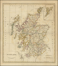
Impressively detailed map of Scotland and its isles, published in London by leading mapmaker Herman Moll.
Each city, market town, and borough is represented by a unique symbol, making it easy to distinguish between them. Universities, important institutions even at this time, are also specifically marked, demonstrating their importance in the broader context of the country. The roads are marked clearly, and their distances are calculated between towns, a feature which would have been of particular interest to travelers of the time.
The Shetland and Orkney Islands, often underrepresented or overlooked due to their distance from the mainland, are given due attention on this map. A large inset at the upper right corner provides detailed representation of these islands, ensuring that no part of Scotland's territory is forgotten.
A dedicatory cartouche to Charles, Duke of Queensbury and Dover and the Lord High Admiral of Scotland, features prominently on the map. This not only serves to honor the Duke but also to reflect the hierarchy and the societal norms of the time.
Charles Douglas, 3rd Duke of Queensberry, was an influential figure in 18th-century Scotland. Born in 1698, he inherited the titles of Marquess of Queensberry, Earl of Drumlanrig and Sanquhar, and Viscount of Nith, Thorthorwald and Ross.
Charles Douglas was also known as the 2nd Duke of Dover. In addition to his many titles, he was appointed Vice Admiral of Scotland, a position of great prestige that placed him in charge of Scotland's naval forces.
![Northern Part of Argyllshire [with] Southern Part of Argyllshire](https://storage.googleapis.com/raremaps/img/small/77784.jpg)
![Scotia Antiqua, qualis pricis temporibus Romanis praesertim, Cognita suit quam in lucem eruere conabatur R Gordonius a Straloch M DC LIII [Ancient Scotia, as it was known in earlier times, particularly to the Romans, attempted to be brought to light by R. Gordonius of Straloch in 1653.]](https://storage.googleapis.com/raremaps/img/small/93094.jpg)