|
||

|

|
|

|
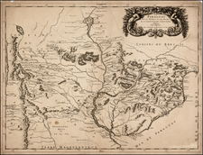
A New and Accurate Map of Peru and the Country of the Amazones, drawn by Emanuel Bowen in London, 1744, offers a detailed depiction of Peru and the Amazon region, tracing the course of the river from its many tributaries to its mouth in the Atlantic Ocean.
The map displays Lake Xarayes as the source of the Paraguay River, a misconception prevalent at the time, reflecting the then-limited understanding of the complex Amazonian hydrological system.
Rich with descriptive annotations, the map provides insights into the geographic understanding and misconceptions of the era, some of which are fantastical or mythological. For instance, the map traces the River of Cuyari, also known as Madera or the Wood River by the Portuguese, highlighting how the Topinambes nation supposedly used this river as a passage into the River Amazones.
In an interesting linguistic note, the map explains how the local Indians distinguish between the River Parana and the River Amazone based on their size. Parana, taking its rise on the frontiers of Peru, is called a "little river" to set it apart from the larger Amazon, which they call Paranaguzu or "great river."
Moreover, Bowen's map makes a speculative nod to the fabled city of El Dorado and the Lake of Parima. Most geographers of the time placed these mythical locations in the region of Guiana, reflecting the enduring legends of immense wealth and golden cities that drew European explorers to the New World.
As an object of its time, this map provides not only a geographical reference but also offers a cultural and historical window into the exploration and understanding of the Amazon region during the 18th century. Its ornate design and meticulous annotations make it a remarkable piece of cartographic history.
Emanuel Bowen (1694?-1767) was a British engraver and print seller. He was most well-known for his atlases and county maps. Although he died in poverty, he was widely acknowledged for his expertise and was appointed as mapmaker to both George II of England and Louis XV of France. His business was carried on by his son, Thomas Bowen. He also trained many apprentices, two of whom became prominent mapmakers, Thomas Kitchin and Thomas Jeffreys.
![[Bahia de Todos Santos] t'Neemen van de Suyker Prysen in de Bay de Tode los Santos Anno 1627](https://storage.googleapis.com/raremaps/img/small/75293.jpg)
![[Peruvian Coast] Sheet XII Peru Cape Lobos to Pescadores Point By Captn. Robert Fitz Roy R.N. The Officers of H.M.S. Beagle 1836](https://storage.googleapis.com/raremaps/img/small/58399.jpg)
![[Rio Grande, Brazil] Rio Grande De S. Pedro](https://storage.googleapis.com/raremaps/img/small/59813.jpg)