|
||

|

|
|

|
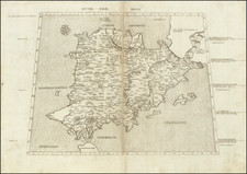
Herman Moll's New and Exact Map of Spain & Portugal, first published in London in 1711, is a highly decorative and meticulously detailed geographical representation of these two nations, reflecting the burgeoning British interest in the Iberian Peninsula during the early 18th century.
Moll's work is notable for the depth of information it provides. The map features intricate divisions of the kingdoms and principalities within Spain and Portugal, each rendered with clarity and precision. These territorial divisions are augmented by an extensive road network, demonstrating the map's utility for overland navigation. The map's accuracy is underscored by its claims of having been "rectify'd according to the Newest Observations."
The title cartouche is resplendent with 16 coats of arms, adding a symbolic depth to the territories represented. In addition, a dedicatory cartouche honors Field Marshal John Campbell, the 2nd Duke of Argyll, who led British forces in Spain during the War of Spanish Succession from 1711 until 1712.
The unique and contentious advertisement included speaks to the competitive nature of map publishing during this period. Moll criticizes his contemporaries for their inaccurate, copied, or deceitfully outdated maps, casting himself as an arbiter of geographical truth. The accusation that others' maps might even pose a hazard at sea lends gravity to his assertions and highlights the seriousness with which he viewed his own work's reliability.
By combining utility and beauty, this map stands as one of the most decorative maps of Spain to emerge in a commercial atlas at the dawn of the 18th century, attesting to Moll's commitment to geographical precision and aesthetic presentation.
State
This is the third of five states, with the imprint of John Bowles substituted for that of Daniel Midwinter Sr., published in 1726.
Herman Moll (c. 1654-1732) was one of the most important London mapmakers in the first half of the eighteenth century. Moll was probably born in Bremen, Germany, around 1654. He moved to London to escape the Scanian Wars. His earliest work was as an engraver for Moses Pitt on the production of the English Atlas, a failed work which landed Pitt in debtor's prison. Moll also engraved for Sir Jonas Moore, Grenville Collins, John Adair, and the Seller & Price firm. He published his first original maps in the early 1680s and had set up his own shop by the 1690s.
Moll's work quickly helped him become a member of a group which congregated at Jonathan's Coffee House at Number 20 Exchange Alley, Cornhill, where speculators met to trade stock. Moll's circle included the scientist Robert Hooke, the archaeologist William Stuckley, the authors Jonathan Swift and Daniel Defoe, and the intellectually-gifted pirates William Dampier, Woodes Rogers and William Hacke. From these contacts, Moll gained a great deal of privileged information that was included in his maps.
Over the course of his career, he published dozens of geographies, atlases, and histories, not to mention numerous sheet maps. His most famous works are Atlas Geographus, a monthly magazine that ran from 1708 to 1717, and The World Described (1715-54). He also frequently made maps for books, including those of Dampier’s publications and Swift’s Gulliver’s Travels. Moll died in 1732. It is likely that his plates passed to another contemporary, Thomas Bowles, after this death.
![(Angra, Madera, Azores, North Africa) De Cust van Barbaryen van out Mamora tot Capo Blanco [with] De Cust van Barbaryen van Capo Blanco Tot Capo de Geer [with] De Reede van Punte del Gada int Eylandt S. Michiels [with] De zuydhoec vant Eylandt Fayal [with] De Reede voor de Stadt Angra int eylandt Tercera [with] De Eylanden van Madera en Porto Santo](https://storage.googleapis.com/raremaps/img/small/83722.jpg)