|
||

|

|
|

|
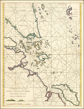
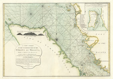
This chart presents a detailed depiction of the bay on the southwest side of Pulo Auore, now known as Paula Aur, Malaysia. Surveyed by William Nicholson in 1763, the map blends chart with coastal profile, depicting the formations of the bay and providing depth measurements, essential for seafaring navigations of the time. The references section elucidates various landmarks and features, such as watering places, sandy bays, and the locations where ships of the English squadron were anchored in January 1765. The chart was published in 1794 by Robert Laurie and James Whittle from their premises in London.
The chart offers remarks and directions that would have been invaluable to sailors. These include descriptions of the land, the nature of the bay's bottom, and specific navigational tips, notably the caution against approaching the mouth of the strait of Singapore at night.
The map showcases the precision and detail that was characteristic of nautical charts of the 18th century, which were indispensable tools for ensuring safe voyages. Such documents not only served practical purposes but also advanced geographical understanding and facilitated exploration and trade during this era.
Robert Laurie (ca. 1755-1836) and James Whittle (1757-1818) formed their Fleet Street, London-based firm upon the 1794 death of their employer Robert Sayer, himself one of the dominant print and mapmakers of the last half of the 18th century.
Laurie & Whittle started managing Sayer's business as early as 1787. They took over all managerial duties when Sayer's health flagged in 1792, and they changed the imprint in 1794 upon his death. Sayer left the two a 21-year lease on the shop (at £100 a year) and on Sayer's Bolt Court premises, as well as an option to acquire stock and equipment at a preferential price of £5,000 payable over three years.
Robert Laurie retired from the firm in 1812, and his role was assumed by his son, Richard Holmes Laurie (1777-1858). The younger Laurie worked with James Whittle until the latter died in 1818. After R. H. Laurie died in 1858, Alexander George Findlay, FRGS (1812-1875) purchased the firm from his daughters. The firm continues today under another name, specializing in yachting charts.
Laurie & Whittle were prolific print and map publishers, and throughout their careers, they produced numerous very important and rare works. They carried on Robert Sayer's atlas business and were responsible for editions of The Complete East-India Pilot and The American Atlas.
![[Singapore & Malaca Strait] Carta Esferica Del Mar de China Comprendido Entre La Isla De Borneo y La Peninsula De Malaca, segun os trabajos mas modernos ingelese y holandeses . . . 1864](https://storage.googleapis.com/raremaps/img/small/62184.jpg)